
Information
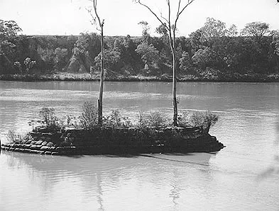
First charted by John Oxley in 1823, this largely submerged ridge of rock posed a very significant navigational issue from the period of first settlement in Brisbane. Despite work being undertaken to create a wider passage, and the building of a stone cairn during the 1860s on one rocky outcrop to draw attention to the submerged reef, it continued to pose navigational issues that affected the sand and gravel and the coal industries in 20th century. The island formed by the cairn was a location of picnics and a symbol of the Seventeen Mile Rocks farming district for approximately 100 years. Further blasting was carried out in 1964-65 as a result of pressure from the gravel and coal industries, and the historic manmade cairn on the south rock was blown out of existence.
Citations
Meg and Margaret Gordon, ‘Thomas Boyland, an adaptive man’, Centenary Suburbs Historical Society, 2008, pp. 17-18, 41-45; Centenary Suburbs Historical Society, ‘The Seventeen-Mile Rocks’, https://cshsoc.files.wordpress.com/2012/08/the-seventeen-mile-rocks.pdf), sighted 17 July 2017.
Image Citations
Man-Made Sandstone Cairn, built 1860s, on the submerged Seventeen-Mile Rocks. Brisbane City Council, Brisbane City Council. Brisbane Images. BCC-B54-16845.
Map References
Currently Searching