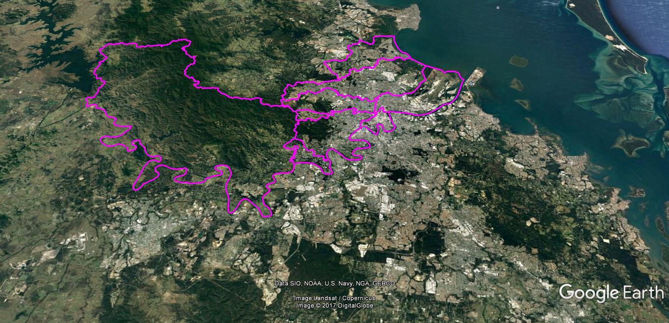
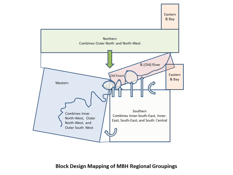
Ideally, in terms of the concept, it would have been good to start at an upper level structure with the 11 regions themselves. Unfortunately, the technology required a simpler upper structure. There were mapping advantages in having a third level placed over the regions, thus the grouping of regions.
Such a third level structure did exist from the beginning of the project, the traditional divide of Brisbane via the river, into Southside and Northside. That Southside-Northside structure was never meant to be a visible part of the mapping but reflected the administrative work of the project which stemmed from the ownership of the project in the Brisbane Southside History Network. To date, there is no Brisbane Northside History Network. There is a Western Suburbs History Network. However, there is nothing for the Eastern or Bay suburbs. A significant part of the project’s mission is to create regional networks of local history organisations, so that they are both strengthen in their own district works and obtain a larger sense of their history on scales beyond the provincial.

The dichotomy of a Southside-Northside structure was not going to work well with the technology and geographic logic, even though that was the paradigm understood in Brisbane’s history. The technology required a simplification at the top level of the mapping, but a duality at the top increased unit numbers below, and the technology refused to comply with the dynamic required. The geographic logic was that the Southside-Northside divide was important, but so were the Western and the Eastern-Bay divisions. Furthermore, the high density of historical sites in the Inner City and the traditional river passage to the seaport and airport facilities represented another challenge for the technology and geographic logic. The solution laid in retaining the Southside-Northside structure but adding another three groupings of the regions: Western suburbs that crossed the river, Eastern and Bay suburbs, existing in two distant areas, above and below the seaport and airport facilities, and a group that is named Old Town and (Old) River, representing a historical density accumulating over four epochs. These are the five groupings of the 11 regions.
Thus the Project’s original dual administrative structure of the Mapping Brisbane Southside History (MBSH) and Mapping Brisbane Northside History (MBNH) is retained. However, this part of the structure has a flexible variation to the five groupings. In thinking about the mapping structure of Southside and Northside there is an adjoined alternative view to the five grouping design. In terms of Mapping Brisbane Southside History, the southern Western, Eastern, and Bay suburbs are part of its design. There is a similar design in terms of the Mapping Brisbane Northside History which also has the Old Town and (Old) River. For the purpose of mapping, we have turned to the five-part upper level where the areas of Western, Eastern & Bay, Old Town & River, are grouped distinctively. Thinking of the mapping designs in this flexible alternative manner avoids the fallacy of the ‘either-or’ mentality.
For the Project, the geographic logic has been Brisbane’s landscape and the human response to the landscape. This has been a conceptual challenge of getting people’s heads around thinking about sites in spatial designs that are larger units of human geography than the traditional idea of historical districts. The major creeks systems on the Southside are Oxley, Norman, Bulimba, and Tingalpa – running from the south to north. The major creeks systems on the Northside are Moggill, Breakfast, Kedron Brook, Downfall-Nundah, and Cabbage Tree –running west to east. Thus the major water systems of the creeks, the river in part, and the Bay, mark out the groupings of the regions. Other natural and human geographic features marked the rest of the boundaries for regions, and then local study areas, the other two levels of mapping focus. One short fall in this design is that the history of the Moreton Bay Islands is not well captured. Only four islands, in southern Moreton Bay, falls into the Brisbane boundaries — Fisherman (now part of the mainland), Mud, St Helena, and Green – but there are regional and historical ties with Moreton and North Stradbroke Islands, and the islands of Redland Bay. In time the project will endeavour to do some mapping in Moreton Bay, but the priority lies on the mainland.
A better understanding of the regional groupings can be seen in the exercise of the original Brisbane Southside and Brisbane Northside design.
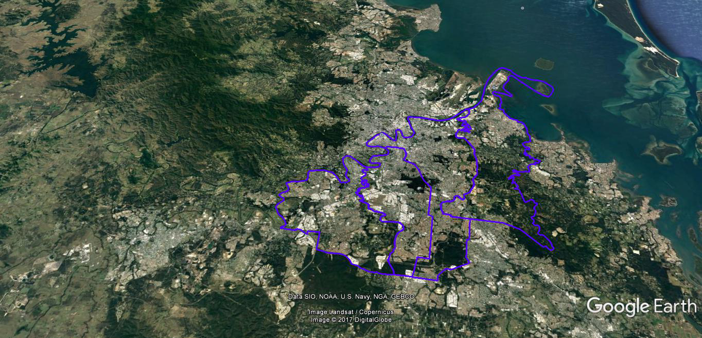
A Group Map of the four stages or regions of the Mapping Brisbane Southside Design
There are four stages or regions in the groupings of the Mapping Brisbane Southside Design. Web links will take you to the full descriptions of the various units. Stage 1 was the pilot project and amalgamated into Stage 2.
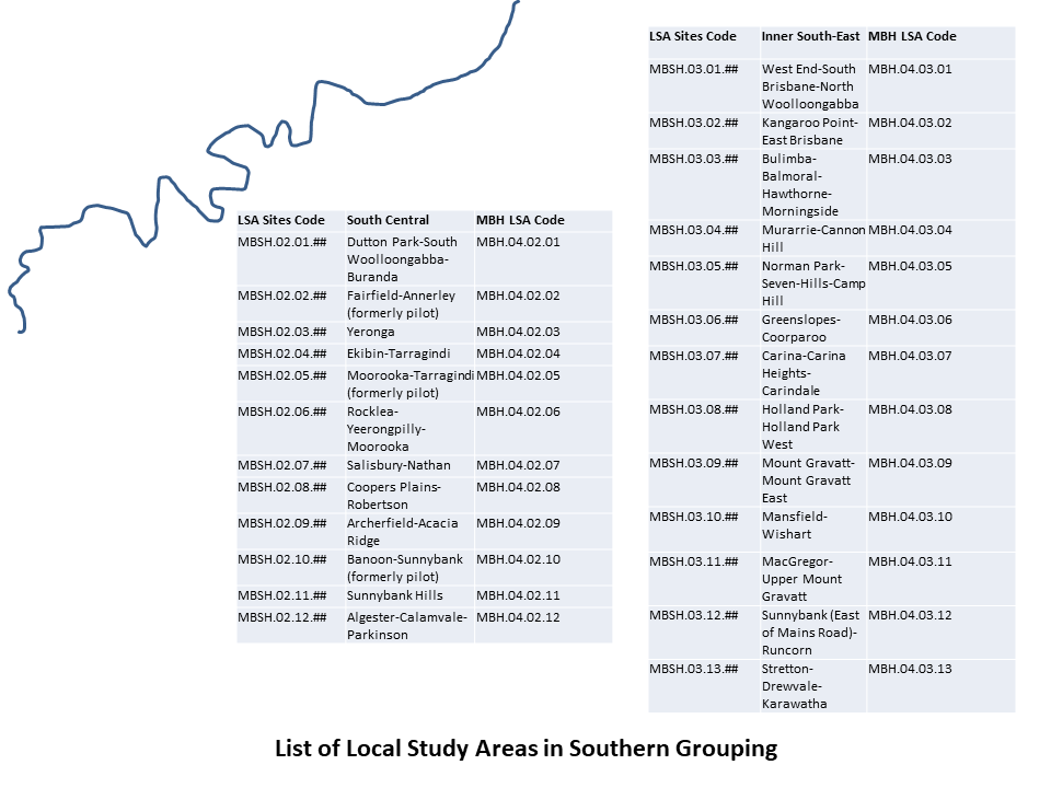
Region: 2. South Central
Grouping: Southern Grouping
The South Central region is enclosed by (West) the Oxley and (East) Norman Creeks (and alignment to their catchment), and by the nineteenth century Brisbane Town boundary (North; Cornwall Street and its alignment) and the current Brisbane City boundary (South). The region is formation of MBH Stage 4.2 Study Areas.
Region: 3. Inner South-East
Grouping: Southern Grouping
The Inner South-East region includes the old South & East Brisbane areas (historically a South-East inner city), and is further enclosed by (West) the Norman and (East) Bulimba Creeks (and alignment to their catchment; in this case, with parts of the Gateway Motorway), and by the Brisbane River (North) and the current Brisbane City boundary (South). The region is formation of MBH Stage 4.3 Study Areas.
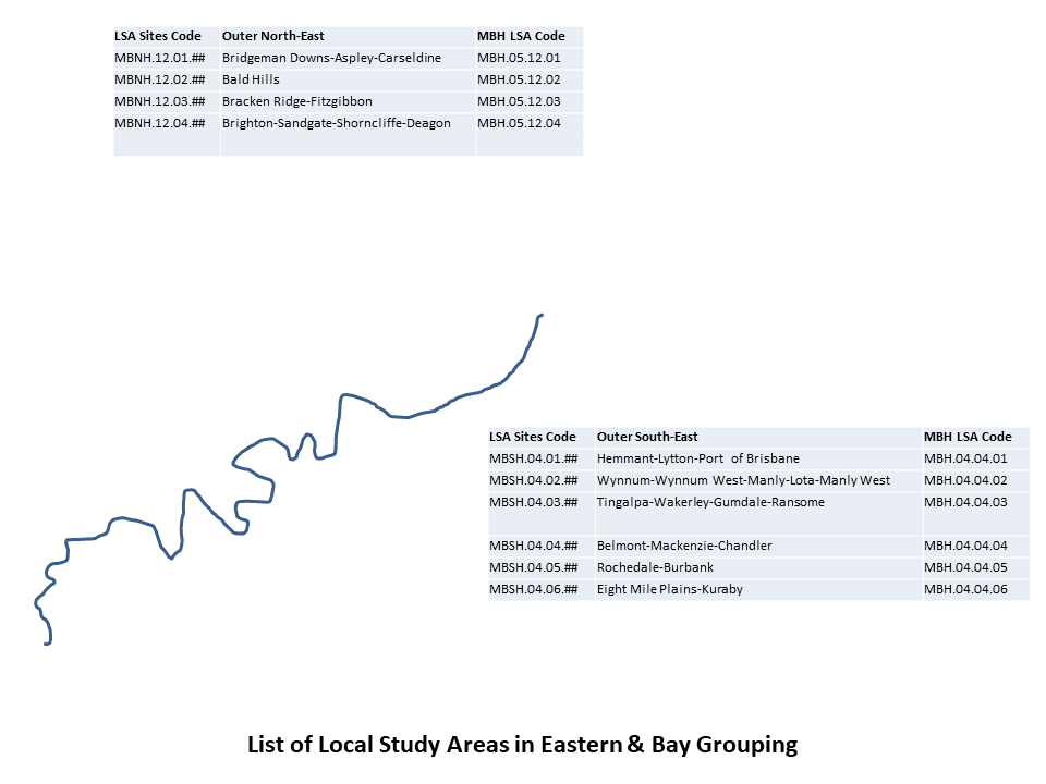
Region: 4. Outer South-East
Grouping: Bay Grouping
See ‘Eastern & Bay Group’ further on.
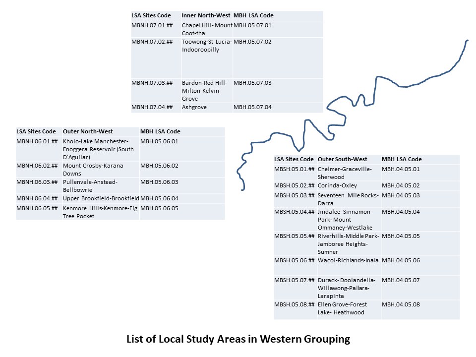
Region: 5. Outer South-West
Grouping: Western Grouping
The Outer South-West region is enclosed by (West) the Brisbane River and (East) Oxley Creek (and alignment to their catchment), and by the Brisbane River (North) and the current Brisbane City boundary (South). The region is formation of MBH Stage 4.5 Study Areas.
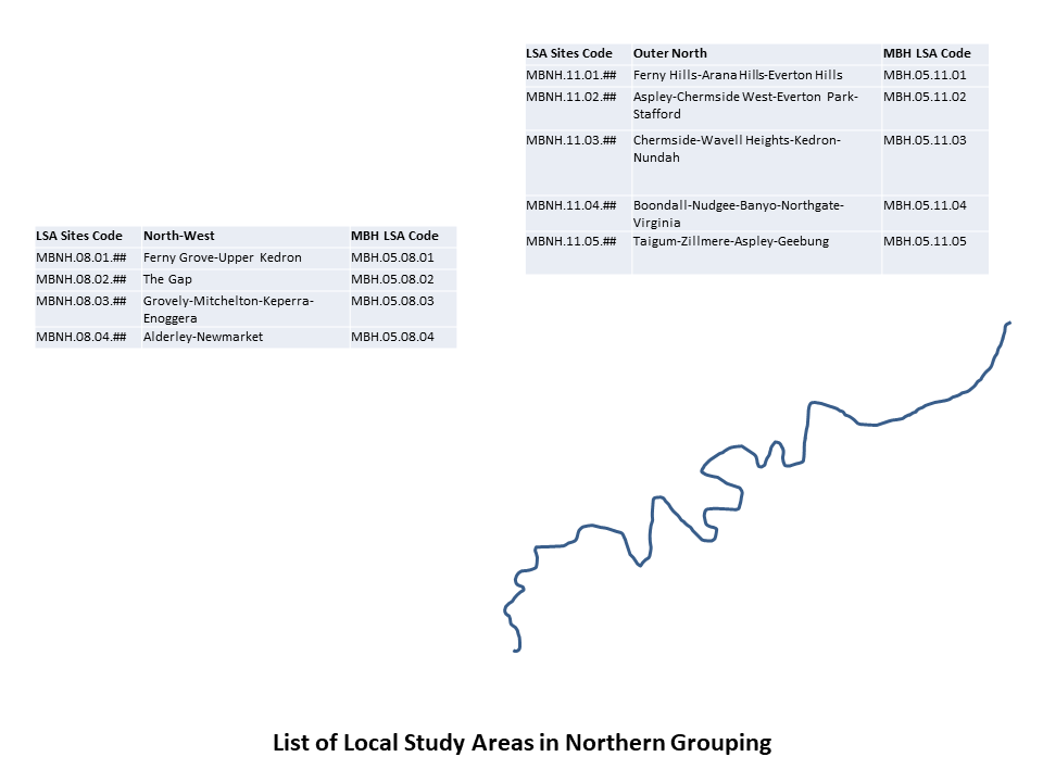
Region: 6. Outer North-West
Grouping: Western Grouping
The Outer North-West region is enclosed by (South) the Brisbane River and (North) Moggill Creek (and alignment to their catchment), and by the Western boundary and the Eastern boundary of the South D’Aguilar Range. The region is formation of MBH Stage 5.6. Study Areas.
Region: 7. Inner North-West
Grouping: Western Grouping
The Inner North-West region is enclosed by (South) the Moggill and (North) ‘Western’ Creek (Milton Drain; and alignment to their catchment), and by the Western boundary of Mount Coot-Tha and the Brisbane River (East). The region is formation of MBH Stage 5.7 Study Areas.
A Group Map of the five stages or regions of the Mapping Brisbane Northside Design (three divisions in the denser area of the Inner City area not shown)
There are nine stages or regions in the groupings of the Mapping Brisbane Northside Design, with the North Central region divided into three small sub-regions. Web links with take you to the full descriptions of the various units.
Region 8. North-West
Grouping: Northern Grouping
The North-West region is enclosed by (South) the Breakfast Creek and (North) Kedron Brook (and alignment to their catchment), and by the current Brisbane City boundary (West) and the Lutwyche Road (East). The region is formation of MBH Stage 5.8 Study Areas.
Region: 11. Outer North
Grouping: Northern Grouping
The Outer North region is enclosed by (South) the Kedron Brook and (North) Cabbage Tree Creek (Tighgum; and alignment to their catchment), and by the Hills area and Cedar Creek (indicator of the Brisbane City Boundary; West) and the shoreline of Moreton Bay (East). The region is formation of MBH Stage 5.11. Study Areas.
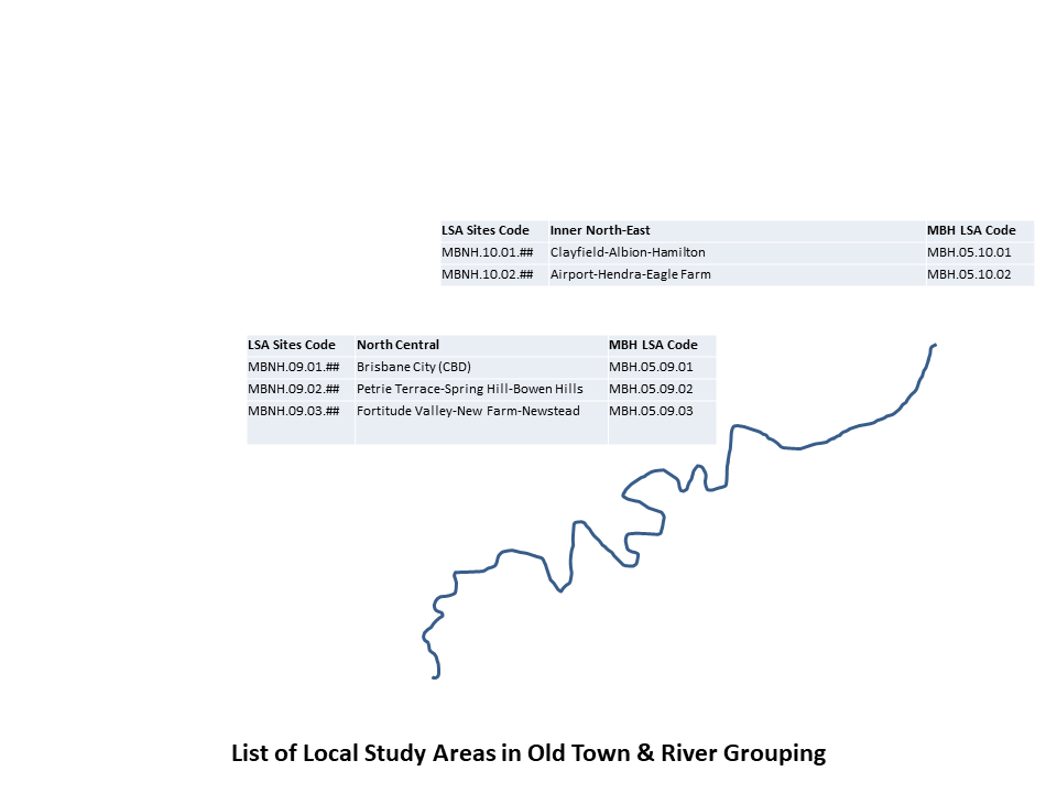
Region: 9. North Central
Grouping: Old Town & River Grouping
The North Central region is enclosed by (South) the Brisbane River and (North) Breakfast Creek (and alignment to their catchment), and by the Inner-City By-Pass (historically Hale Street and Yorks Hollow; West) and the Brisbane River (East). The region is formation of MBH Stage 5.9 Study Areas.
Region: 10. Inner North-East
Grouping: Old Town & River Grouping
The Inner North-East region is enclosed by (South) Breakfast Creek & Brisbane River and (North) Kedron Brook & shoreline of Moreton Bay (and alignment to their catchment), and by the Lutwyche Road (West) and the Brisbane River (East). The region is formation of MBH Stage 5.10 Study Areas.

Region: 4. Outer South-East
Grouping: Eastern & Bay Grouping
The Outer South-East region is enclosed by (West) the Bulimba Creek with parts of the Gateway Motorway and (East) shoreline of Moreton Bay & Tingalpa Creek (and alignment to their catchment), and by the Brisbane River (North) and the current Brisbane City boundary (South). The region is formation of MBH Stage 4.4 Study Areas.
Region: 12. Outer North-East
Grouping: Eastern & Bay Grouping
The Outer North-East region is enclosed by (South) Cabbage Tree (Tighgum) Creek and (North) South Pine & North Pine Rivers (and alignment to their catchment), and by the Old Northern Road (West) and the shoreline of Moreton Bay (East). The region is formation of MBH Stage 5.12 Study Areas.