Indigenous Sites across Brisbane Southside: Ray Kerkhove
Stage 4.4 Study Areas
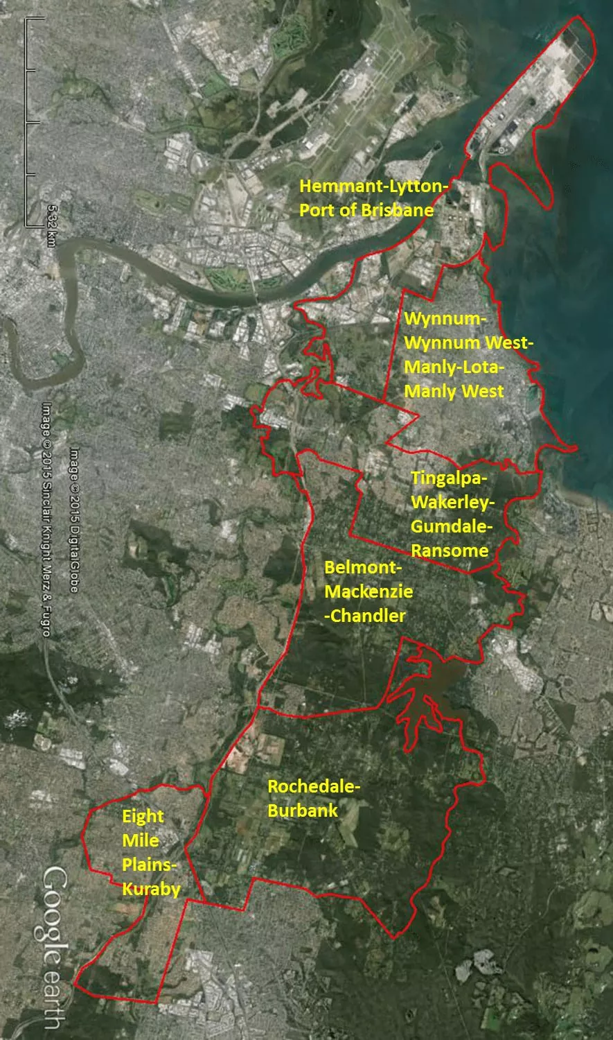
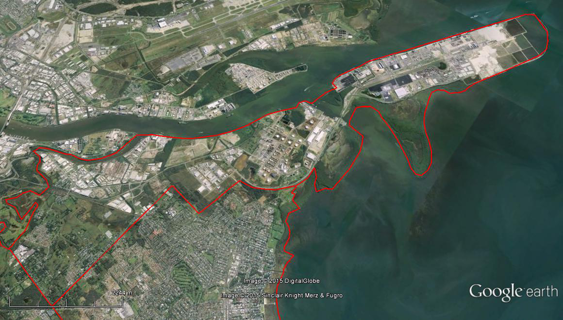
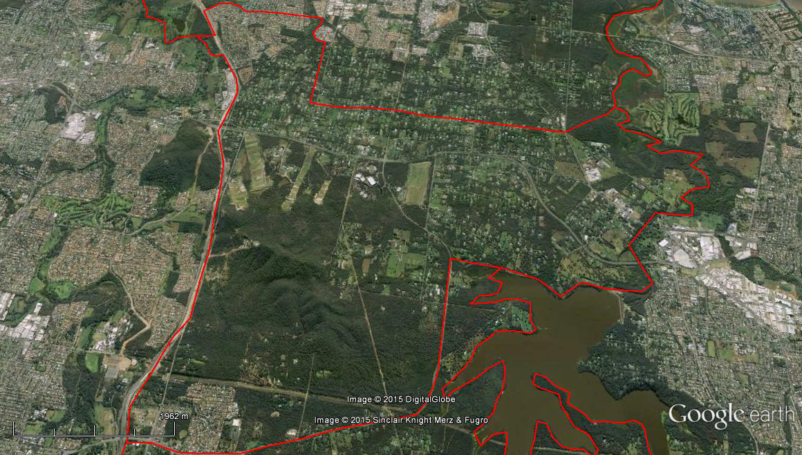
The Spatial Description of the Hemmant-Lytton-Port of Brisbane Local Area Study
1 mile = 1.609 km
Straight Line Between Start-Finish Line:
6.83 miles (10.99 km) on Northern West-East boundary, mouth of the Bulimba Creek to the low-tide point of the Port of Brisbane on the southern edge of the mouth of the Brisbane River
5.11 miles (8.22 km) on Eastern North-South boundary (Part 1), the low-tide point of the Port of Brisbane on the southern edge of the mouth of the Brisbane River, following the low-tide level of Moreton Bay, to the southern boundary of the Port of Brisbane at the edge of Elanora Park.
3.43 miles (5.52 km) on Eastern North-South boundary (Part 2), the southern boundary of the Port of Brisbane at the edge of Elanora Park, along the Wynnum West suburban boundary, aligned with Kianawah Road, to the Fleming and Wynnum Roads Intersection.
0.99 miles (1.59 km) on Southern East-West boundary, Fleming and Wynnum Roads Intersection to Bulimba Creek, following the Creek downstream, to mouth of the Bulimba Creek.
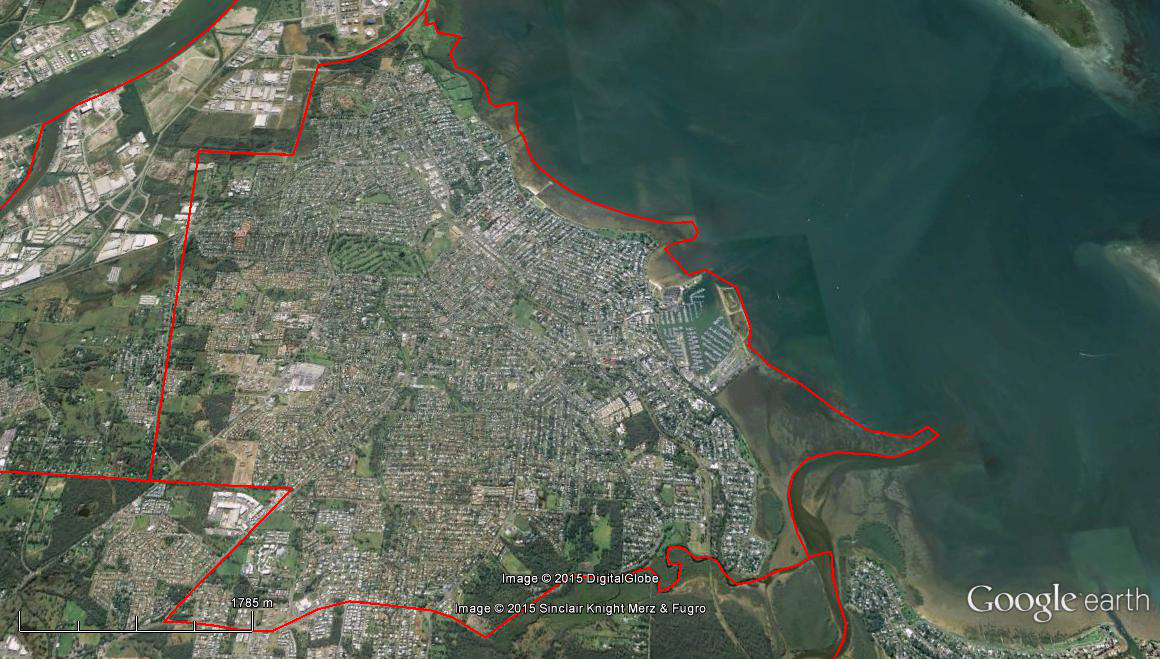
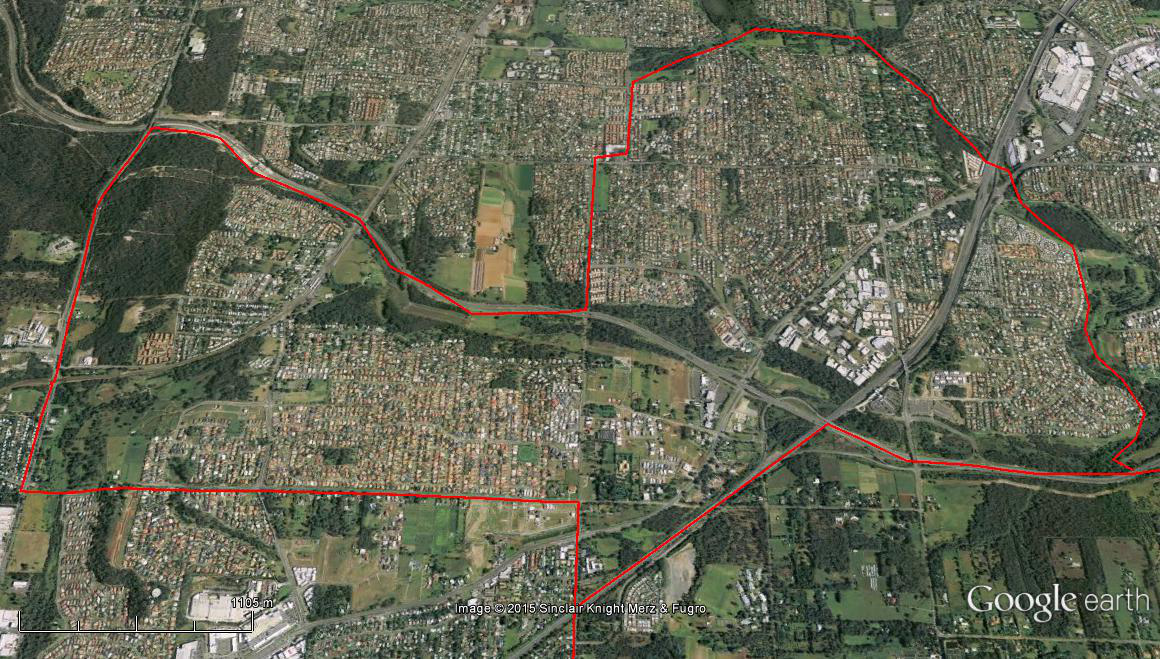
The Spatial Description of the Wynnum-Wynnum West-Manly-Lota-Manly West Local Area Study
1 mile = 1.609 km
Straight Line Between Start-Finish Line:
4.18 miles (6.73 km) on Eastern North-South boundary, the southern boundary of the Port of Brisbane at the edge of Elanora Park, following the low-tide level of Moreton Bay, to mouth of Tingalpa Creek.
3.19 miles (5.13 km) on Southern East-West boundary, mouth of Tingalpa Creek, following Lota Creek, via the Manly & Green Camp Roads Intersection, to Manly & Wondall Roads Intersection.
4.02 miles (6.47 km) on Western South-North boundary, Manly & Wondall Roads Intersection, via a point (27°27’58.62″S, 153° 9’17.48″E) on Wondall Road (near Radford Road), the Fleming and Wynnum Roads Intersection, along the Wynnum West suburban boundary, aligned with Kianawah Road, to the southern boundary of the Port of Brisbane at the edge of Elanora Park.
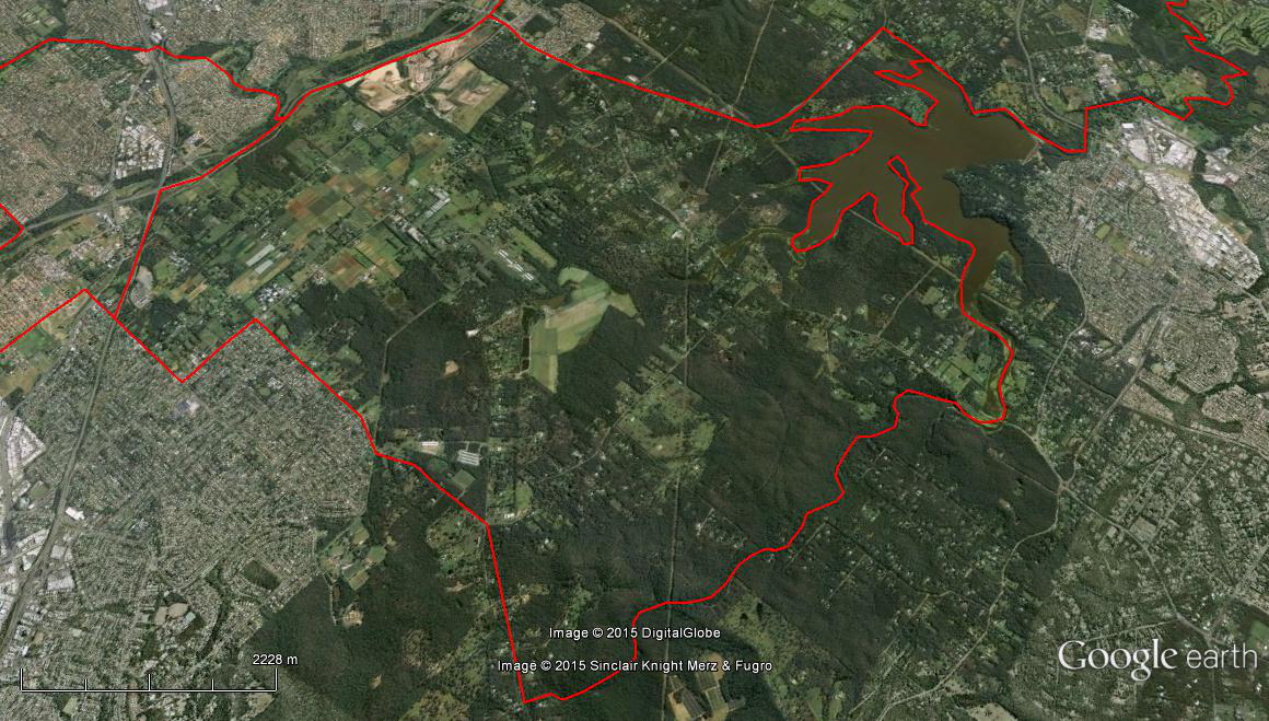
The Spatial Description of the Tingalpa-Wakerley-Gumdale-Ransome Local Area Study
1 mile = 1.609 km
Straight Line Between Start-Finish Line:
1.91 miles (3.07 km) on Eastern North-South boundary, mouth of the Tingalpa Creek, following the Creek upstream, to a point south (27°29’59.10″S, 153°11’6.77″E) on the Tingalpa Creek.
4.27 miles (6.87 km) on Southern East-West boundary, a point (27°29’59.10″S, 153°11’6.77″E) on the Tingalpa Creek, near the Chelsea and New Cleveland Roads Intersection, via a point west (27°29’59.90″S, 153° 8’16.23″E) on London Road near Stanbrough Road (Belmont suburban boundary), a point north (27°29’0.66″S, 153° 8’20.36″E) near New Cleveland Road, a point west (27°28’54.92″S, 153° 7’7.86″E) on the Gateway Motorway, a point south (27°29’12.84″S, 153° 7’16.90″E) on the Gateway Motorway, to a point east (27°29’16.97″S, 153° 6’47.53″E) on the Bulimba Creek.
1.82 miles (2.93 km) on Western South-North boundary, a point (27°29’16.97″S, 153° 6’47.53″E) on the Bulimba Creek, to a point (27°27’43.73″S, 153° 7’34.10″E) on Bulimba Creek near Fleming and Wynnum Roads Intersection .
4.48 miles (7.21 km) on Northern West-East boundary, a point (27°27’43.73″S, 153° 7’34.10″E) on Bulimba Creek, via Fleming and Wynnum Roads Intersection, a point (27°27’58.62″S, 153° 9’17.48″E) on Wondall Road (near Radford Road), Manly & Wondall Roads Intersection, Manly & Green Camp Roads Intersection, following Lota Creek, to mouth of Tingalpa Creek.
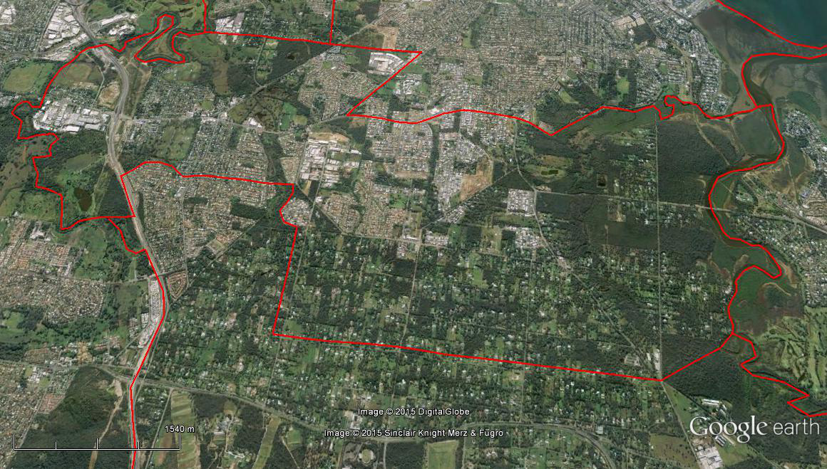
The Spatial Description of the Belmont-Mackenzie-Chandler Local Area Study
1 mile = 1.609 km
Straight Line Between Start-Finish Line:
2.11 miles (3.40 km) on Eastern North-South boundary, a point (27°29’59.10″S, 153°11’6.77″E) on the Tingalpa Creek, following Tingalpa Creek upstream, into Tingalpa Reservoir, a point south (27°31’32.17″S, 153° 9’55.78″E) on the western bank of the Tingalpa Reservoir, following the Mount Gravatt-Capalaba Road, to where the Mount Gravatt-Capalaba Road meets the Gateway Motorway,
4.04 miles (6.50 km) on Western South-North boundary, where the Mount Gravatt-Capalaba Road meets the Gateway Motorway, following the Gateway Motorway, to a point east (27°29’16.97″S, 153° 6’47.53″E) on the Bulimba Creek.
4.27 miles (6.87 km) on Northern West-East boundary, a point (27°29’16.97″S, 153° 6’47.53″E) on the Bulimba Creek, via a point east (27°29’12.84″S, 153° 7’16.90″E) on the Gateway Motorway, a point north (27°29’0.66″S, 153° 8’20.36″E) near New Cleveland Road, a point west (27°28’54.92″S, 153° 7’7.86″E) on the Gateway Motorway, a point west (27°29’59.90″S, 153° 8’16.23″E) on London Road near Stanbrough Road (Belmont suburban boundary), across to near the Chelsea and New Cleveland Roads Intersection, to a point (27°29’59.10″S, 153°11’6.77″E) on the Tingalpa Creek.
The Spatial Description of the Rochedale-Burbank Local Area Study
1 mile = 1.609 km
Straight Line Between Start-Finish Line:
5.23 miles (8.42 km) on Eastern North-South boundary, a point (27°31’32.21″S, 153° 9’55.54″E) on the Tingalpa Reservoir, following the western bank of Tingalpa Reservoir, the following of Tingalpa Creek upstream, to where Tingalpa Creek goes under Ford Road.
3.58 miles (5.76 km) on Southern East-West boundary, where Tingalpa Creek goes under Ford Road, via Priestdale & Ford Roads Intersection, Priestdale & Rochedale Roads Intersection, Rochedale & Underwood Roads Intersection, to where Underwood Road meets the Pacific Motorway.
3.35 miles (5.39 km) on Western South-North boundary, where Underwood Road meets the Pacific Motorway, via Gateway Motorway, to where the Mount Gravatt-Capalaba Road meets the Gateway Motorway.
3.20 miles (5.15 km) on Northern West-East boundary, where the Mount Gravatt-Capalaba Road meets the Gateway Motorway, following the Mount Gravatt-Capalaba Road, to a point north (27°31’32.17″S, 153° 9’55.78″E) on the western bank of the Tingalpa Reservoir.
The Spatial Description of the Eight Mile Plains-Kuraby Local Area Study
1 mile = 1.609 km
Straight Line Between Start-Finish Line:
3.55 miles (5.71 km) on Eastern North-South boundary, a point south (27°34’5.65″S, 153° 6’26.40″E) on the Gateway Motorway where one branch of the Bulimba Creek heads west towards Runcorn, following the Gateway Motorway, via Pacific Motorway, where Underwood Road meets the Pacific Motorway, Underwood & Millers Roads Intersection, following Millers Road, to an alignment on Compton Road.
1.43 miles (2.30 km) on Southern East-West boundary, an alignment with Millers Road on Compton Road, to where Compton Road meets the Gateway Motorway.
3.60 miles (5.79 km) on Western South-North boundary, where Compton Road meets the Gateway Motorway, via where Underwood Road meets the Gateway Motorway (27°35’30.26″S, 153° 5’42.13″E), Daws and Warrigal Roads Intersection, Daws Road until it reaches Bulimba Creek, Bulimba Creek downstream, to a point south (27°34’5.65″S, 153° 6’26.40″E) on the Gateway Motorway.