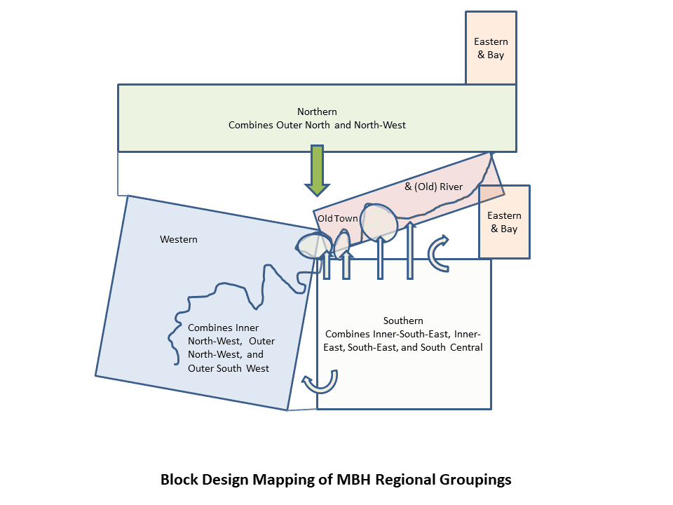
The basic groupings of Brisbane regions, going in a clockwise direction,
Originally, the aim of the MBH Project was a singular, unified, map for the whole of the Brisbane area. Unfortunately, the technology was outpaced by our vision and we were limited to having five groupings for the 11 regions. There are a few important advantages, however, in the new block segmented design. The design always better viewing of dense clusters. More importantly, it provides alternative ways for different Brisbane regions to be understood. Our fundamental group structure has been the traditional divide of the Brisbane River, between Brisbane Southside and Brisbane Northside. Much of the city’s history is understood on this structure. The Project will retain that approach into terms of the Brisbane Southside History Network, and the possibility of a northside network. Nevertheless, the five groupings of regions demonstrate other networks, that of the historical inner city with its access through the air and sea port corridor, the Eastern and Bay suburbs, and the western suburbs which paid less regard to the river divide.
More information on the groupings of regions can be found here.

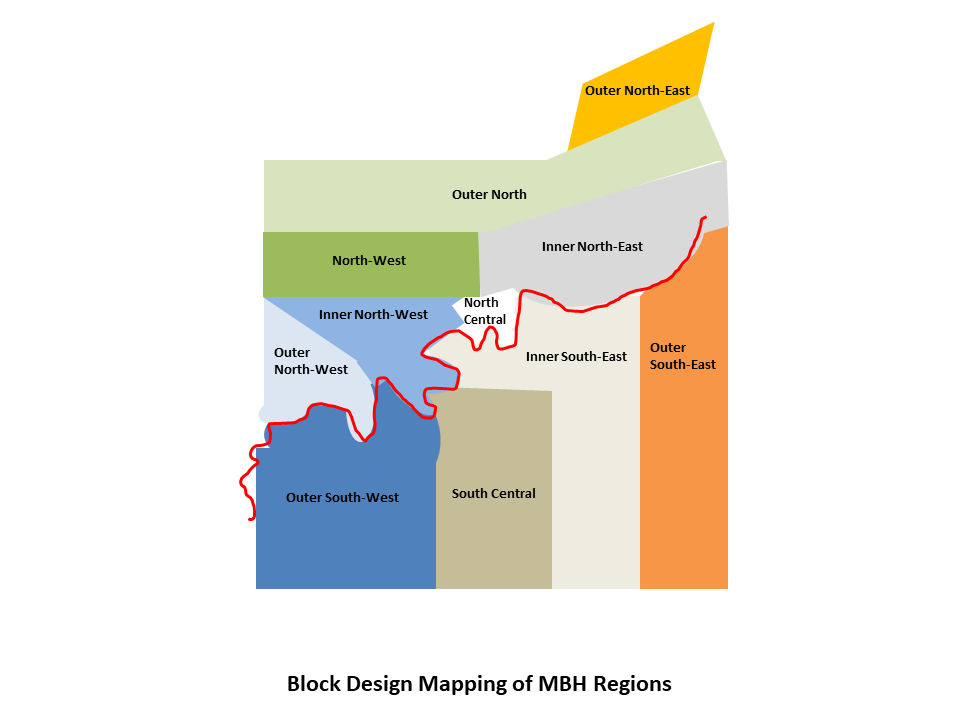
Next, we have the 11 regions of Brisbane (the original ‘stages’ retained):
One might ask why 11, not 10 or 12, but again the answer is the technological requirements combined with the geographical logic which had been set in the original stages (the pilot stage being number 1, amalgamated into No. 2 region).
More information on the regions can be found here.
Finally, there are the local study areas, in the regions, and in the groupings of regions. And the table of the 66 local study areas is as follows:
| LSA Sites Code | Grouping | Regions | Local Area Study | MBH LSA Code |
| MBSH.02.01.## | Southern | South Central | Dutton Park-South Woolloongabba-Buranda | MBH.04.02.01 |
| MBSH.02.02.## | Southern | South Central | Fairfield-Annerley (formerly pilot) | MBH.04.02.02 |
| MBSH.02.03.## | Southern | South Central | Yeronga | MBH.04.02.03 |
| MBSH.02.04.## | Southern | South Central | Ekibin-Tarragindi | MBH.04.02.04 |
| MBSH.02.05.## | Southern | South Central | Moorooka-Tarragindi (formerly pilot) | MBH.04.02.05 |
| MBSH.02.06.## | Southern | South Central | Rocklea-Yeerongpilly-Moorooka | MBH.04.02.06 |
| MBSH.02.07.## | Southern | South Central | Salisbury-Nathan | MBH.04.02.07 |
| MBSH.02.08.## | Southern | South Central | Coopers Plains-Robertson | MBH.04.02.08 |
| MBSH.02.09.## | Southern | South Central | Archerfield-Acacia Ridge | MBH.04.02.09 |
| MBSH.02.10.## | Southern | South Central | Banoon-Sunnybank (formerly pilot) | MBH.04.02.10 |
| MBSH.02.11.## | Southern | South Central | Sunnybank Hills | MBH.04.02.11 |
| MBSH.02.12.## | Southern | South Central | Algester-Calamvale-Parkinson | MBH.04.02.12 |
| MBSH.03.01.## | Southern | Inner South-East | West End-South Brisbane-North Woolloongabba | MBH.04.03.01 |
| MBSH.03.02.## | Southern | Inner South-East | Kangaroo Point-East Brisbane | MBH.04.03.02 |
| MBSH.03.03.## | Southern | Inner South-East | Bulimba-Balmoral-Hawthorne-Morningside | MBH.04.03.03 |
| MBSH.03.04.## | Southern | Inner South-East | Murarrie-Cannon Hill | MBH.04.03.04 |
| MBSH.03.05.## | Southern | Inner South-East | Norman Park-Seven-Hills-Camp Hill | MBH.04.03.05 |
| MBSH.03.06.## | Southern | Inner South-East | Greenslopes-Coorparoo | MBH.04.03.06 |
| MBSH.03.07.## | Southern | Inner South-East | Carina-Carina Heights-Carindale | MBH.04.03.07 |
| MBSH.03.08.## | Southern | Inner South-East | Holland Park-Holland Park West | MBH.04.03.08 |
| MBSH.03.09.## | Southern | Inner South-East | Mount Gravatt-Mount Gravatt East | MBH.04.03.09 |
| MBSH.03.10.## | Southern | Inner South-East | Mansfield-Wishart | MBH.04.03.10 |
| MBSH.03.11.## | Southern | Inner South-East | MacGregor-Upper Mount Gravatt | MBH.04.03.11 |
| MBSH.03.12.## | Southern | Inner South-East | Sunnybank (East of Mains Road)-Runcorn | MBH.04.03.12 |
| MBSH.03.13.## | Southern | Inner South-East | Stretton-Drewvale-Karawatha | MBH.04.03.13 |
| MBSH.04.01.## | Eastern & Bay | Outer South-East | Hemmant-Lytton-Port of Brisbane | MBH.04.04.01 |
| MBSH.04.02.## | Eastern & Bay | Outer South-East | Wynnum-Wynnum West-Manly-Lota-Manly West | MBH.04.04.02 |
| MBSH.04.03.## | Eastern & Bay | Outer South-East | Tingalpa-Wakerley-Gumdale-Ransome | MBH.04.04.03 |
| MBSH.04.04.## | Eastern & Bay | Outer South-East | Belmont-Mackenzie-Chandler | MBH.04.04.04 |
| MBSH.04.05.## | Eastern & Bay | Outer South-East | Rochedale-Burbank | MBH.04.04.05 |
| MBSH.04.06.## | Eastern & Bay | Outer South-East | Eight Mile Plains-Kuraby | MBH.04.04.06 |
| MBSH.05.01.## | Western | Outer South-West | Chelmer-Graceville-Sherwood | MBH.04.05.01 |
| MBSH.05.02.## | Western | Outer South-West | Corinda-Oxley | MBH.04.05.02 |
| MBSH.05.03.## | Western | Outer South-West | Seventeen Mile Rocks-Darra | MBH.04.05.03 |
| MBSH.05.04.## | Western | Outer South-West | Jindalee- Sinnamon Park- Mount Ommaney-Westlake | MBH.04.05.04 |
| MBSH.05.05.## | Western | Outer South-West | Riverhills-Middle Park-Jamboree Heights-Sumner | MBH.04.05.05 |
| MBSH.05.06.## | Western | Outer South-West | Wacol-Richlands-Inala | MBH.04.05.06 |
| MBSH.05.07.## | Western | Outer South-West | Durack- Doolandella-Willawong-Pallara-Larapinta | MBH.04.05.07 |
| MBSH.05.08.## | Western | Outer South-West | Ellen Grove-Forest Lake- Heathwood | MBH.04.05.08 |
| MBNH.06.01.## | Western | Outer North-West | Kholo-Lake Manchester-Enoggera Reservoir (South D’Aguilar) | MBH.05.06.01 |
| MBNH.06.02.## | Western | Outer North-West | Mount Crosby-Karana Downs | MBH.05.06.02 |
| MBNH.06.03.## | Western | Outer North-West | Pullenvale-Anstead-Bellbowrie | MBH.05.06.03 |
| MBNH.06.04.## | Western | Outer North-West | Upper Brookfield-Brookfield | MBH.05.06.04 |
| MBNH.06.05.## | Western | Outer North-West | Kenmore Hills-Kenmore-Fig Tree Pocket | MBH.05.06.05 |
| MBNH.07.01.## | Western | Inner North-West | Chapel Hill- Mount Coot-tha | MBH.05.07.01 |
| MBNH.07.02.## | Western | Inner North-West | Toowong-St Lucia-Indooroopilly | MBH.05.07.02 |
| MBNH.07.03.## | Western | Inner North-West | Bardon-Red Hill-Milton-Kelvin Grove | MBH.05.07.03 |
| MBNH.07.04.## | Western | Inner North-West | Ashgrove | MBH.05.07.04 |
| MBNH.08.01.## | Northern | North-West | Ferny Grove-Upper Kedron | MBH.05.08.01 |
| MBNH.08.02.## | Northern | North-West | The Gap | MBH.05.08.02 |
| MBNH.08.03.## | Northern | North-West | Grovely-Mitchelton-Keperra-Enoggera | MBH.05.08.03 |
| MBNH.08.04.## | Northern | North-West | Alderley-Newmarket | MBH.05.08.04 |
| MBNH.09.01.## | Old Town & River | North Central | Brisbane City (CBD) | MBH.05.09.01 |
| MBNH.09.02.## | Old Town & River | North Central | Petrie Terrace-Spring Hill-Bowen Hills | MBH.05.09.02 |
| MBNH.09.03.## | Old Town & River | North Central | Fortitude Valley-New Farm-Newstead | MBH.05.09.03 |
| MBNH.10.01.## | Old Town & River | Inner North-East | Clayfield-Albion-Hamilton | MBH.05.10.01 |
| MBNH.10.02.## | Old Town & River | Inner North-East | Airport-Hendra-Eagle Farm | MBH.05.10.02 |
| MBNH.11.01.## | Northern | Outer North | Ferny Hills-Arana Hills-Everton Hills | MBH.05.11.01 |
| MBNH.11.02.## | Northern | Outer North | Aspley-Chermside West-Everton Park-Stafford | MBH.05.11.02 |
| MBNH.11.03.## | Northern | Outer North | Chermside-Wavell Heights-Kedron-Nundah | MBH.05.11.03 |
| MBNH.11.04.## | Northern | Outer North | Boondall-Nudgee-Banyo-Northgate-Virginia | MBH.05.11.04 |
| MBNH.11.05.## | Northern | Outer North | Taigum-Zillmere-Aspley-Geebung | MBH.05.11.05 |
| MBNH.12.01.## | Eastern & Bay | Outer North-East | Bridgeman Downs-Aspley-Carseldine | MBH.05.12.01 |
| MBNH.12.02.## | Eastern & Bay | Outer North-East | Bald Hills | MBH.05.12.02 |
| MBNH.12.03.## | Eastern & Bay | Outer North-East | Bracken Ridge-Fitzgibbon | MBH.05.12.03 |
| MBNH.12.04.## | Eastern & Bay | Outer North-East | Brighton-Sandgate-Shorncliffe-Deagon | MBH.05.12.04 |
There are two different columns of codes here. The first coded column provides the way each site will have a unique identifier. The other coded column provides a unique identifier for each local study area.
More information on the local study areas can be found here.