The Mapping Brisbane History Project has 11 regions of Brisbane.
The regions are:
2. South Central
3. Inner South-East
4. Outer South-East
5. Outer South-West
6. Outer North-West
7. Inner North-West
8. North-West
9. North Central
10. Inner North-East
11. Outer North
12. Outer North-East
One might ask why 11, not 10 or 12, but again the answer is the technological requirements combined with the geographical logic which had been set in the original stages (the pilot stage being number 1, amalgamated into No. 2 region). The original idea reflected the administration of mapping process over the life of the project. Thus the MBSH and MBNH coding of the stages, which group the local study areas appears re- aligned into MBH Stage 4 and 5.

The South Central region is enclosed by (West) the Oxley and (East) Norman Creeks (and alignment to their catchment), and by the nineteenth century Brisbane Town boundary (North; Cornwall Street and its alignment) and the current Brisbane City boundary (South). The region is formation of MBH Stage 4.2 Study Areas.
The South Central region is the history of major southern pathways to and from the Centre, whether the centre be the pre-invasive or pre-European settled Aboriginal communities in York Hollow and into the Garden Point Peninsula, the Convict Brisbane River settlement, the Brisbane Township or the modern City. Based on pre-1823 indigenous pathways, the roads of Ipswich (Limestone), Beaudesert (Mount Lindsay), Boundary-Capalaba (original Cleveland), Beenleigh (the first road to Logan), Logan (the second road), and ‘Old’ Cleveland (second road) were the first transportation routes for agriculture and other commercial trade between Ipswich, the Darling Downs, and Moreton Bay shipping; and it developed extensively earlier than the system that developed on the Northside. The South Central region is the hub in that Southern system.
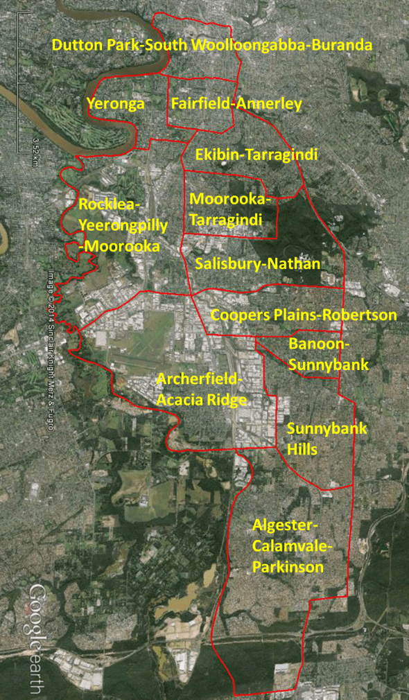
The Inner South-East region includes the old South & East Brisbane areas (historically a South-East inner city), and is further enclosed by (West) the Norman and (East) Bulimba Creeks (and alignment to their catchment; in this case, with parts of the Gateway Motorway), and by the Brisbane River (North) and the current Brisbane City boundary (South). The region is formation of MBH Stage 4.3 Study Areas.
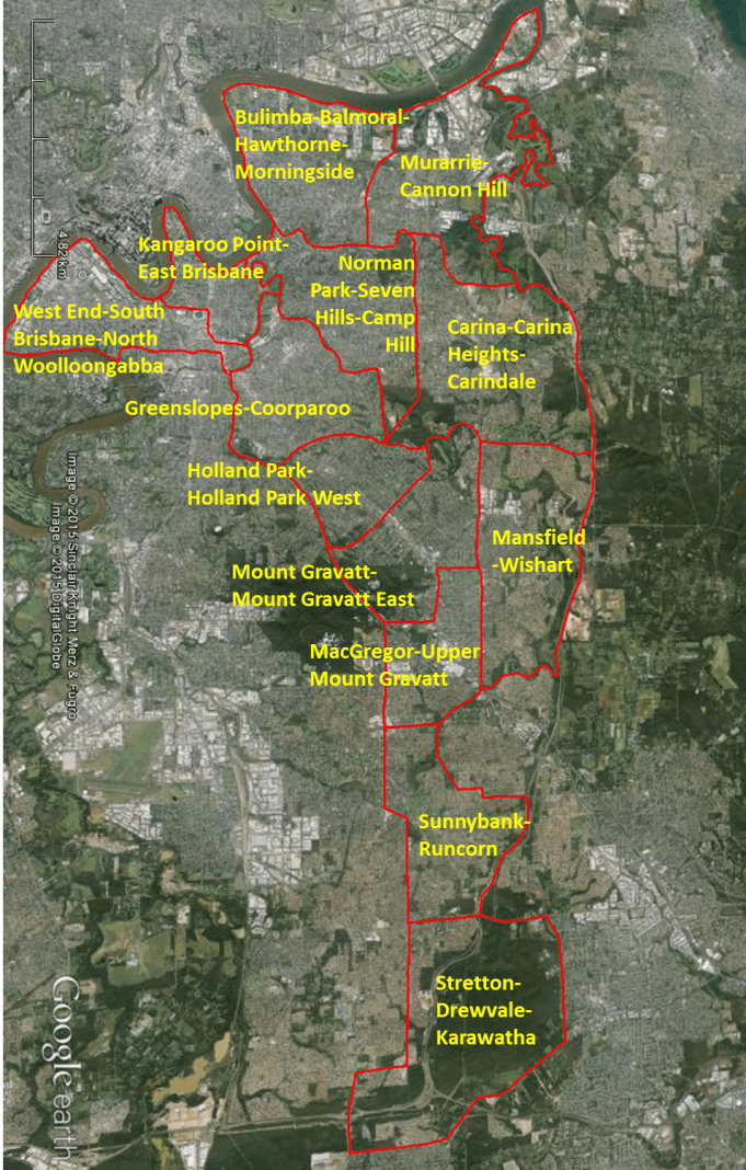
The Inner South-East region is the history of what traditionally was called ‘Brisbane South’ and ‘Brisbane East’, and holds two sub-regions together. The first is the South Brisbane Town area with its outer adjoining districts, encapsulating northern Woolloongabba, Kangaroo Point, East Brisbane and Dutton Park. These were the areas that were inside Cornwall Street traditional township boundary. The second sub-region is the south-east urban growth that followed the Logan pathway. Earlier than that which followed the Ipswich and Beaudesert pathways, the major part of the City’s push has been in the south-east direction. The areas on the eastern side of the Main Road ridgeline, and as it meet the Bulimba Creek at the southern end, were the last and largest agriculture and forested (timber) districts. Mount Gravatt is a major natural landmark for Brisbane, and access is through this region.
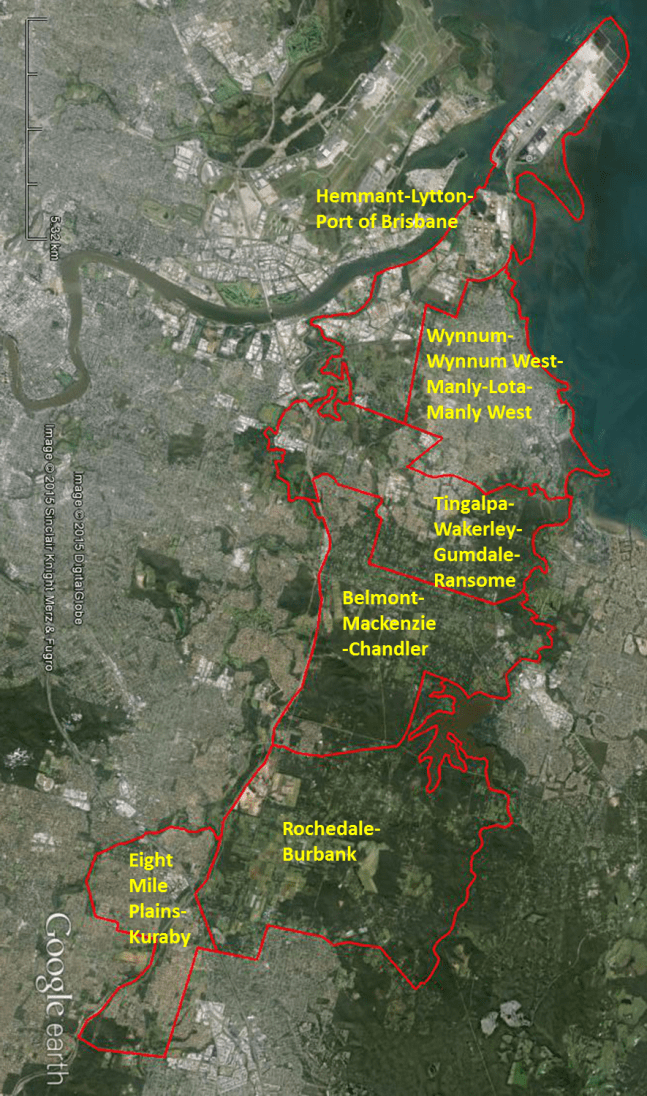
The Outer South-East region is enclosed by (West) the Bulimba Creek with parts of the Gateway Motorway and (East) shoreline of Moreton Bay & Tingalpa Creek (and alignment to their catchment), and by the Brisbane River (North) and the current Brisbane City boundary (South). The region is formation of MBH Stage 4.4 Study Areas.
The Outer South-East region is the history of the southern Moreton Bay area that existed inside the City boundaries, and the bush districts that circled around Mount Petrie and Mount Cotton on the outskirts of the City boundaries. In that sphere was the agricultural region of Eight-Mile Plains and Rochedale. These districts are also included in the early history of the Central South and South-East regions. The reason why these districts are seen more in the history of the Outer South-East is the way the Logan pathway, both in terms of road and rail, tended to push those districts into the affairs of that outer region. There is also the natural boundary in the Bulimba Creek tributaries and the hills of Eight-Mile Plains (ironically) and Kuraby.
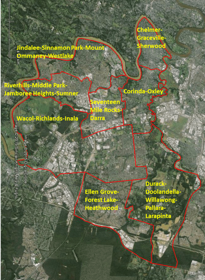
The Outer South-West region is enclosed by (West) the Brisbane River and (East) Oxley Creek (and alignment to their catchment), and by the Brisbane River (North) and the current Brisbane City boundary (South). The region is formation of MBH Stage 4.5 Study Areas.
The Outer South-West region is the history of outlaying districts west of Oxley Creek. Oxley was the next western Township before arriving into the Brisbane area. However, there were earlier parts of Outer South-West that was developed, as outstations and pastoral properties. In later times the region followed the South Central’s role as a major transportation hub. In what was called The Blunder area, the Limestone and then Ipswich pathways were re-designed several times. With the Walter Taylor Bridge and Oxley Road, an alternative north-south route was created. Graceville Avenue and Sherwood Road provided better east-west passage in the southern regions. However, it was in the late twentieth and early twentieth-first century, that new and large intersecting pathways were added, with the Centenary Motorway and Ipswich-Logan By-Pass.
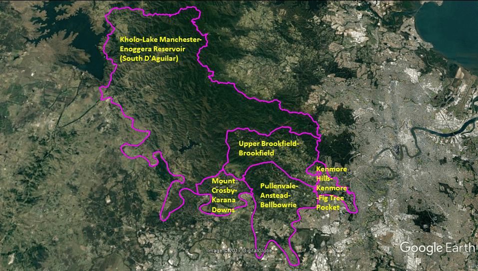
The Outer North-West region is enclosed by (South) the Brisbane River and (North) Moggill Creek (and alignment to their catchment), and by the Western boundary and the Eastern boundary of the South D’Aguilar Range. The region is formation of MBH Stage 5.6. Study Areas. The Outer North-West region is enclosed by (South) the Brisbane River and (North) Moggill Creek (and alignment to their catchment), and by the Western boundary and the Eastern boundary of the South D’Aguilar Range. The region is formation of MBH Stage 5.6. Study Areas.
The Outer North-West region is the history of forested (timber) districts with a scattering of farms. The region had a significant role in the history of the Brisbane River, in terms of transportation, water storage, and flow control. The region houses Brisbane’s most pristine nature reserves.
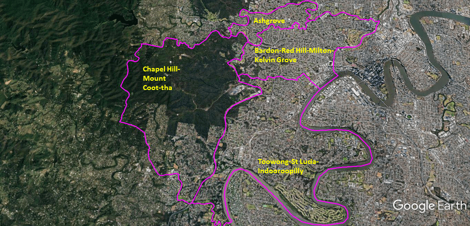
The Inner North-West region is enclosed by (South) the Moggill and (North) ‘Western’ Creek (Milton Drain; and alignment to their catchment), and by the Western boundary of Mount Coot-Tha and the Brisbane River (East). The region is formation of MBH Stage 5.7 Study Areas.
The Inner North-West region is the history of the western pathway (Moggill Road). The addition of the railway strengthen the role of the region as a major traffic corridor, and today is well-expressed in the ‘recent’ creation of the Legacy Tunnel adjoining to the Centenary Motorway. Mount Coot-Tha is also a major natural landmark for Brisbane, and access is through this region.
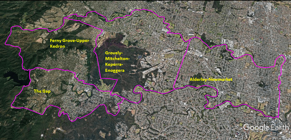
The North-West region is enclosed by (South) the Breakfast Creek and (North) Kedron Brook (and alignment to their catchment), and by the current Brisbane City boundary (West) and the Lutwyche Road (East). The region is formation of MBH Stage 5.8 Study Areas.
The North-West region is the history of the many valleys, hills, and the mountains that circle around The Gap. The region had a significant role in Brisbane’s early water supply. The region is also the gateway to Mount Glorious, Mount Nebo, and the Samford Valley. These were important areas for the tourist industry and environmental management.

The North Central region is enclosed by (South) the Brisbane River and (North) Breakfast Creek (and alignment to their catchment), and by the Inner-City By-Pass (historically Hale Street and Yorks Hollow; West) and the Brisbane River (East). The region is formation of MBH Stage 5.9 Study Areas.
The North Central region is the history of Old Brisbane Town, as well as being the modern city. The region has the largest cluster of heritage sites.
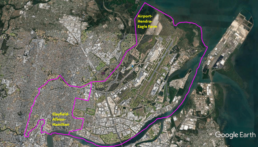
The Inner North-East region is enclosed by (South) Breakfast Creek & Brisbane River and (North) Kedron Brook & shoreline of Moreton Bay (and alignment to their catchment), and by the Lutwyche Road (West) and the Brisbane River (East). The region is formation of MBH Stage 5.10 Study Areas.
The Inner North-East region is closely linked to the history of the Inner City, being the old seaport area, and later the Brisbane Airport district. The large rises (river hills) above Breakfast Creek and Brisbane River hold a significant number of the oldest and wealthiest properties in Brisbane.
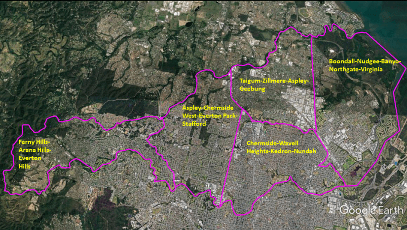
The Outer North region is enclosed by (South) the Kedron Brook and (North) Cabbage Tree Creek (Tighgum; and alignment to their catchment), and by the Hills area and Cedar Creek (indicator of the Brisbane City Boundary; West) and the shoreline of Moreton Bay (East). The region is formation of MBH Stage 5.11. Study Areas.
The Outer North region is a history of early outlying agricultural areas, rural industries, and the largest northern area of the suburban sprawl. It parallels the history of the Outer Southern regions (Outer South-West, South Central, and Outer South-East).
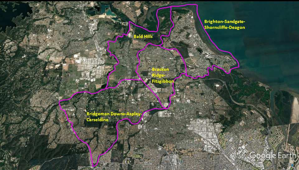
The Outer North-East region is enclosed by (South) Cabbage Tree (Tighgum) Creek and (North) South Pine & North Pine Rivers (and alignment to their catchment), and by the Old Northern Road (West) and the shoreline of Moreton Bay (East). The region is formation of MBH Stage 5.12 Study Areas.
The Outer North-East region is the history of the northern Moreton Bay within the City boundaries, along with the history of areas south of South Pine River where the City boundaries creep northward. Apart from the once-tourist districts of Brighton-Sandgate, the region has only been in recent times seen as part of Brisbane suburbia.