Indigenous Sites across Brisbane Northside: Ray Kerkhove
Stage 5.7 Study Areas
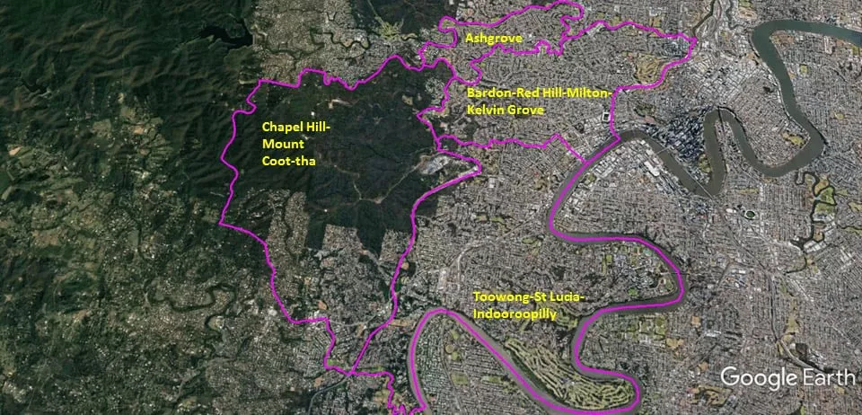
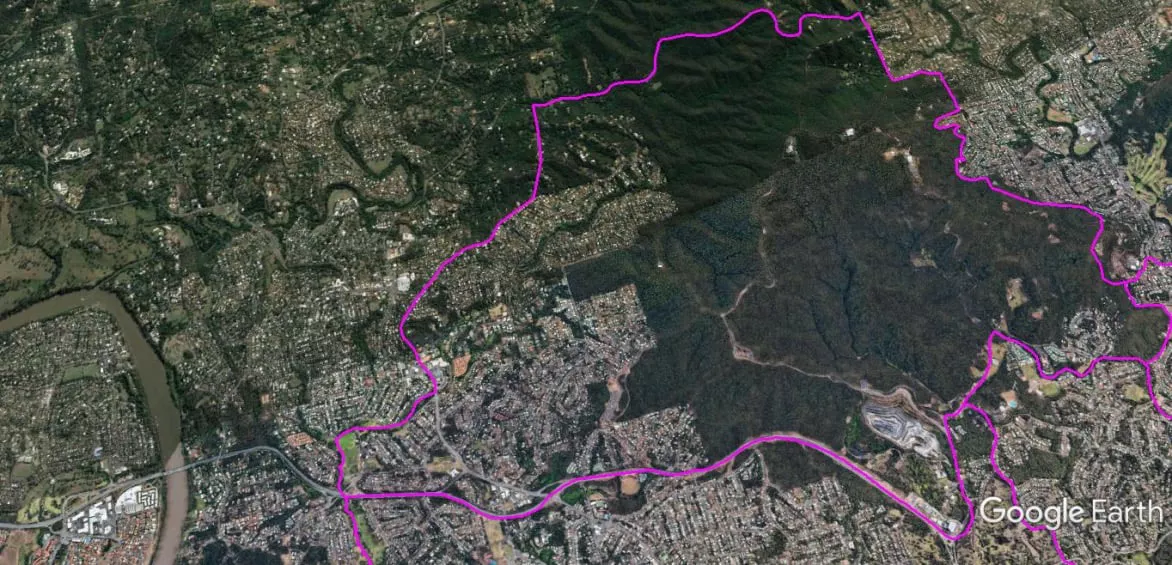
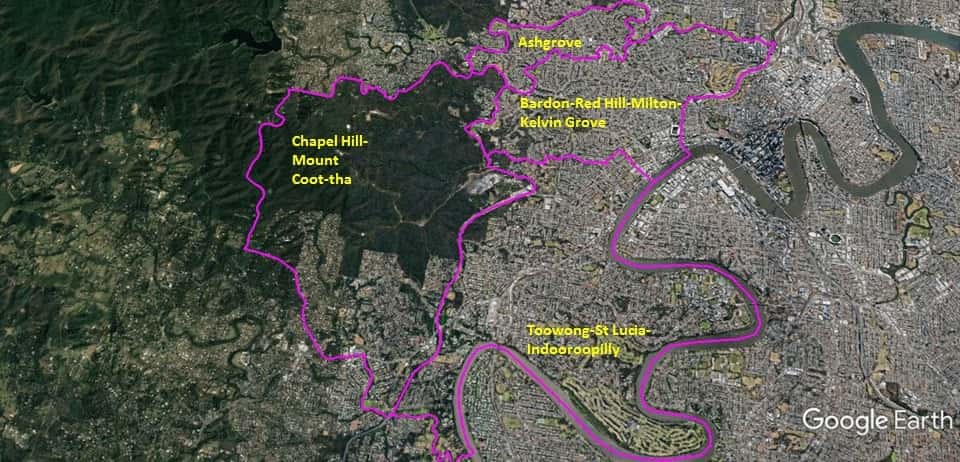
The Spatial Description of the Chapel Hill-Mount Coot-tha Local Area Study
1 mile = 1.609 km
15.47 miles (24.9 km) encirclement of MBNH LSA 6
3.12 miles (5.02 km) on Northern West-East boundary, a point (Lat. 27°27’26.12″S, Lon. 152°55’49.17″E) on Dillon Road, following eastward the tree-line of the Brisbane State Forest (northern edge of Mount Coot-Tha; above the private property boundaries), until this pathway reaches at a point (Lat. 27°27’20.25″S, Lon. 152°58’31.47″E) on Ithaca Creek.
6.37 miles (10.26 km) on Eastern North-South boundary, at a point (Lat. 27°27’20.25″S, Lon. 152°58’31.47″E) on Ithaca Creek, follow Ithaca Creek to the bridge of Sir Samuel Griffith Drive, follow Sir Samuel Griffith Drive southward, the drive becomes Mouth Coot-Tha Road eastward, at roundabout follow Western Freeway southward to the Western Freeway crossing of Cubberie Creek.
0.35 miles (0.56 km) on Southern East-West boundary, Western Freeway crossing of Cubberie Creek, following the creek to the Moggill Road bridge, following Moggill Road westward until Cedarleigh Road, follow Cedarleigh Road which becomes Bielby Road northward, at the intersection of Hillcrest Place and Bielby Road an alignment into Hillcrest Place to a point (Lat. 27°29’21.20″S, Lon. 152°55’33.18″E) on Gap Creek Road.
5.63 miles (09.06 km) on Western South-North boundary, a point (Lat. 27°29’21.20″S, Lon. 152°55’33.18″E) on Gap Creek Road, northward on Gap Creek Road which becomes Dillon Road northward to a point (Lat. 27°27’26.12″S, Lon. 152°55’49.17″E) on Dillon Road.
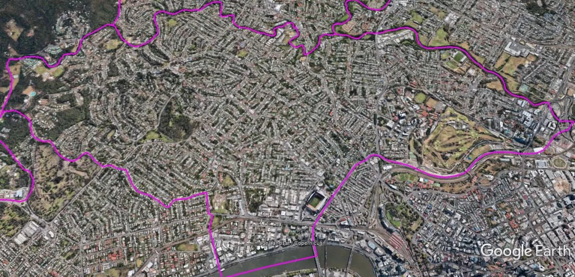
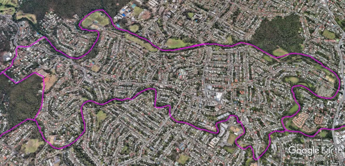
The Spatial Description of the Bardon-Red Hill- Milton-Kelvin Grove Local Area Study
1 mile = 1.609 km
10.79 miles (19.33 km) encirclement of MBNH LSA 8
5.30 miles (8.52 km) on Northern West-East boundary, from the junction of Ithaca and Ashgrove (Breakfast) creeks, follow creek until a point (lat. 27°26’39.42″S, Lon. 153° 1’59.26″E) on the Inter-City Bypass Loop above the south bank of the Breakfast Creek.
1.52 miles (4.43 km) on Eastern North-South boundary, a point (lat. 27°26’39.42″S, Lon. 153° 1’59.26″E) on the Inter-City Bypass Loop above the south bank of the Breakfast Creek following the Inner-City Bypass to the Brisbane River (Go Between Bridge), following Brisbane River downstream to the Milton Drain.
2.52 miles (4.05 km) on Southern East-West boundary, a straight alignment from the mouth of the Milton Drain on the Brisbane River, up to the canal line (via Milton Park) of former creek to Milton Road, follow Torwood Street from Milton Road to the T-Junction Intersection with Haig Road southward, becomes Birdwood Terrace, follow Birdwood Terrace westward, to the T-Junction Intersection with Sir Samuel Griffith Drive.
1.45 miles (2.33 km) on Western South-North boundary, the T-Junction Intersection with Sir Samuel Griffith Drive and Birdwood Terrace, follow Sir Samuel Griffith Drive until is bridge over Ithaca Creek, follow Ithaca Creek downstream until the junction with Ashgrove (Breakfast) creek.
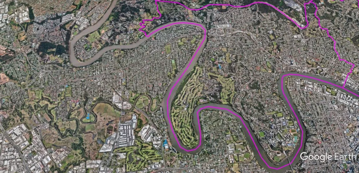
The Spatial Description of the Toowong-St Lucia-Indooroopilly Local Area Study
1 mile = 1.609 km
19.37 miles (31.14 km) encirclement of MBNH LSA 7
2.52 miles (4.05 km) on Northern West-East boundary, the T-Junction Intersection of Sir Samuel Griffith Drive and Birdwood Terrace, follow Birdwood Terrace eastward, becomes Haig Road, follow Haig Road north ward until to the T-Junction Intersection with Torwood Street, follow Torwood Street to Milton Road, follow the canal line (via Milton Park) of former creek in a straight alignment to the mouth of the Milton Drain on the Brisbane River.
10.07 miles (16.21km) on Eastern North-South boundary, mouth of the Milton Drain on the Brisbane River, follow Brisbane River downstream to the mouth of Cubberie Creek.
2.52 miles (4.03 km) on Southern East-West boundary, mouth of Cubberie Creek following the creek to the Western Freeway crossing.
4.26miles (6.85 km) on Western South-North boundary, the Western Freeway crossing of Cubberie Creek, follow the Western Freeway northward, exit to the roundabout at Mount Coot-tha Road, follow Mount Coot-tha Road westward to Sir Samuel Griffith Drive, follow Sir Samuel Griffith Drive northward to the T-Junction Intersection of Sir Samuel Griffith Drive and Birdwood Terrace.
The Spatial Description of the Ashgrove Local Area Study
1 mile = 1.609 km
9.04 miles (14.57 km) encirclement of MBNH LSA 9
4.84 miles (7.80 km) on Northern West-East boundary, Greenlanes Road crossing over Breakfast (Enoggera-Ashgrove) Creek, follow Breakfast Creek (known in that part as also Enoggera Creek or Ashgrove Creek) eastward, until the junction with Ithaca Creek.
3.02 miles (4.86 km) on Eastern North-South boundary, the junction with Ithaca and Ashgrove (Breakfast) Creeks, follow Ithaca Creek upstream until a point (Lat. 27°27’20.25″S, Lon. 152°58’31.47″E) on Ithaca Creek.
0.71 miles (1.15 km) on Southern East-West boundary, a point (Lat. 27°27’20.25″S, Lon. 152°58’31.47″E) on Ithaca Creek, follow tree-line of the Brisbane State Forest (northern edge of Mount Coot-Tha; above the private property boundaries) westward, until this pathway reaches Greenmont Close.
0.47 miles (0.76 km) on Western South-North boundary, follow Greenmont Close into Glenquarie Place, follow Glenquarie Place northward to Waterworks Road, follow Waterworks Road to Greenlanes Road, follow Greenlanes Road to the crossing over Breakfast (Enoggera-Ashgrove) Creek.