Indigenous Sites across Brisbane Northside: Ray Kerkhove
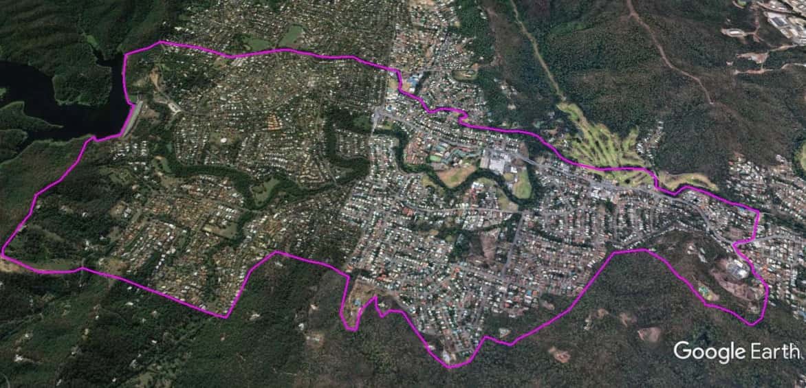
Stage 5.8 Study Areas
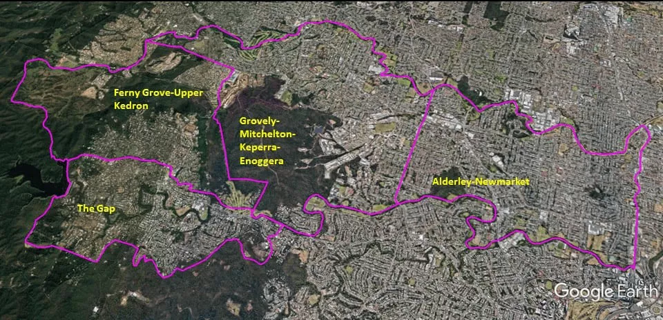
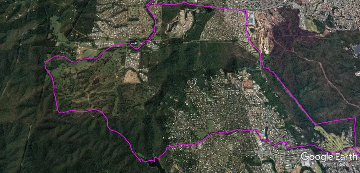
The Spatial Description of the Ferny Grove-Upper Kedron Local Area Study
1 mile = 1.609 km
11.19 miles (18 km) encirclement of MBNH LSA 10
1.42 miles (2.29 km) on Northern West-East boundary, a point (Lat. 27°25’11.20″S, Lon. 152°54’17.15″E) at the natural drainage into the headwater of the Cedar Creek, following Cedar Creek to the Upper Kedron Road bridge, follow Upper Kedron Road eastward into Samford Road until the T-Junction Intersection with Settlement Road.
2.75 miles (4.42 km) on Eastern North-South boundary, T-Junction Intersection of Samford and Settlement Roads, follow Settlement Road southward until a point (Lat 27°25’34.83″S, Lon. 152°56’55.75″E) on Settlement Road being a fire access track, follow fire access track southward, to a point (Lat. 27°26’22.96″S, Lon. 152°57’22.91″E) at the end of the fire access track (above Ashgrove Golf Course), following ridge-line eastward to a point (Lat. 27°26’23.55″S, Lon. 152°57’50.65″E) at a mountain peak (above the end of Bennett Road), a straight line descending to a point (Lat. 27°26’43.10″S, Lon. 152°57’45.55″E) on Ashgrove (Breakfast) Creek near the Bennett Road bridge.
2.57 miles (4.13 km) on Southern East-West boundary, a point (Lat. 27°26’43.10″S, Lon. 152°57’45.55″E) on Ashgrove (Breakfast) Creek near the Bennett Road bridge, follow Ashgrove (Breakfast) Creek upstream to the junction with Fish Creek, follow Fish Creek upstream, the creek peats-out near Alutha Road (in Wittonga Park), follow Alutha Road westward and an alinement to a point (Lat 27°26’23.74″S, Lon. 152°55’35.95″E) on Mount Nebo Road, a line down the slope to a point Lat. 27°26’26.24″S, Lon. 152°55’34.37″E), and then to a point (Lat. 27°26’45.80″S, Lon. 152°55’31.16″E) on the northern shore of the Enoggera Reservoir.
4.45 miles (7.16 km) on Western South-North boundary, a point (Lat. 27°26’45.80″S, Lon. 152°55’31.16″E) on the northern shore of the Enoggera Reservoir following the boundary of the Brisbane City Council northward to a point (Lat. 27°25’11.20″S, Lon. 152°54’17.15″E) at the natural drainage into the headwater of the Cedar Creek (flows into Kedron Brook).

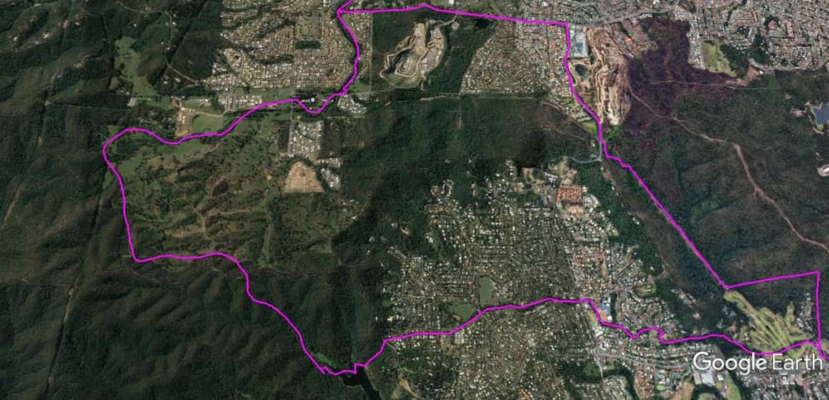
The Spatial Description of The Gap Local Area Study
1 mile = 1.609 km
8.42 miles (13.54 km) encirclement of MBNH LSA 11
3.04 miles (4.88 km) on Northern West-East boundary, a point (Lat. 27°26’45.80″S, Lon. 152°55’31.16″E) on the northern shore of the Enoggera Reservoir, , a line up the slope to a point Lat. 27°26’26.24″S, Lon. 152°55’34.37″E), to a point (Lat 27°26’23.74″S, Lon. 152°55’35.95″E) on Mount Nebo Road, an alinement to Alutha Road, follow Alutha Road westward, headwater of Fish Creek, follow Fish Creek downstream, to the junction with follow Ashgrove (Breakfast) Creek, follow Ashgrove (Enoggera-Breakfast) Creek downstream to Greenlanes Road crossing.
0.50 miles (0.80 km) on Eastern North-South boundary, the Greenlanes Road crossing over Breakfast (Enoggera-Ashgrove) Creek, follow Greenlanes Road southward to Waterworks Road, follow Waterworks Road westward to Glenquarie Place, follow Glenquarie Place southward until Greenmont Close.
3.68 miles (5.93 km) on Southern East-West boundary, follow Greenmont Close into the tree-line of the Brisbane State Forest, follow the tree-line westward (northern edge of Mount Coot-Tha; above the private property boundaries), until this pathway reaches a point (Lat. 27°27’26.12″S, Lon. 152°55’49.17″E) on Dillon Road.
1.20 miles (1.93 km) on Western South-North boundary, a point (Lat. 27°27’26.12″S, Lon. 152°55’49.17″E) on Dillon Road, across to a peak at a point (Lat. 27°27’27.54″S, Lon. 152°55’33.56″E), and follow the ridge line to the southern shore of the reservoir to a point (Lat. 27°26’55.00″S, Lon. 152°55’33.76″E), following the reservoir wall northward to a point (Lat. 27°26’45.80″S, Lon. 152°55’31.16″E) on the northern shore of the Enoggera Reservoir.
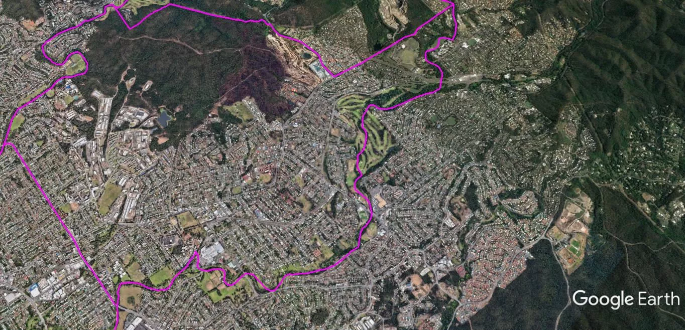
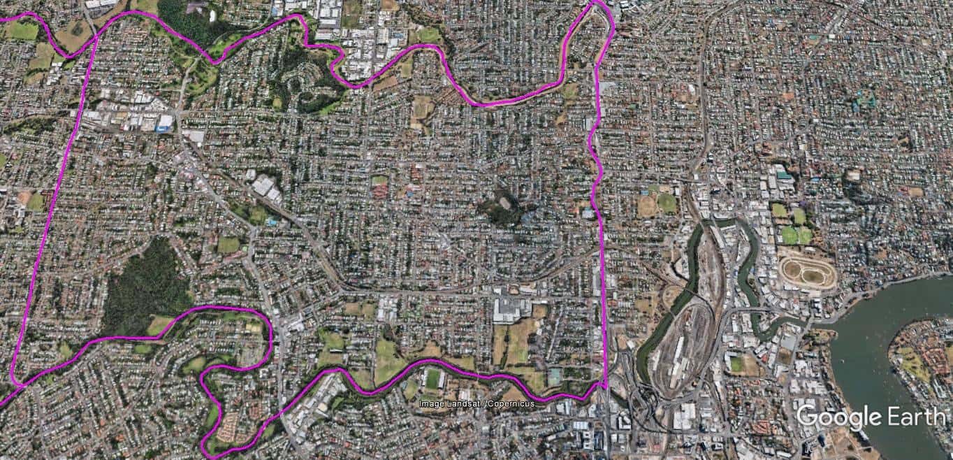
The Spatial Description of the Grovely-Mitchelton-Keperra-Enoggera Local Area Study
1 mile = 1.609 km
13.41 miles (21.57 km) encirclement of MBNH LSA 12
6.09 miles (9.80 km) on Northern West-East boundary, Upper Kedron Road bridge crossing of Cedar Creek, following Cedar Creek to its junction with Kedron Brook, following Kedron Brook downstream to the South Pine Road bridge .
1.87 miles (3.0 km) on Eastern North-South boundary, South Pine Road bridge crossing of Kedron Brook, follow South Pine Road southward, becomes Wardell Street, joins into Stewart Road just before the Steward Road bridge over Breakfast (Ashgrove) Creek .
2.70 miles (4.35 km) on Southern East-West boundary, Steward Road bridge crossing, follow Breakfast Creek upstream to a point (Lat. 27°26’43.10″S, Lon. 152°57’45.55″E) on Ashgrove (Breakfast) Creek near the Bennett Road bridge.
2.75 miles (4.42 km) on Western South-North boundary, a point (Lat. 27°26’43.10″S, Lon. 152°57’45.55″E) on Ashgrove (Breakfast) Creek near the Bennett Road bridge, a straight line ascending to a point (Lat. 27°26’23.55″S, Lon. 152°57’50.65″E) at a mountain peak (above the end of Bennett Road), following ridge-line westward to a point (Lat. 27°26’22.96″S, Lon. 152°57’22.91″E) at the end of a fire access track (above Ashgrove Golf Course), follow fire access track northward, until a point (Lat 27°25’34.83″S, Lon. 152°56’55.75″E) on Settlement Road (being the start of the fire access track), follow Settlement Road northward to the T-Junction Intersection with Samford Roads, follow Samford Road eastward into Upper Kedron Road until the Upper Kedron Road bridge over Cedar Creek.

The Spatial Description of the Alderley-Newmarket Local Area Study
1 mile = 1.609 km
12.11 miles (19.47 km) encirclement of MBNH LSA 13
4.00 miles (6.43 km) on Northern West-East boundary, South Pine Road bridge crossing of Kedron Brook, following Kedron Brook downstream to Gympie-Lutwyche Road Bridge.
2.20 miles (3.54 km) on Eastern North-South boundary, Gympie-Lutwyche Road Bridge over Kedron Brook, Lutwyche Road southward to Breakfast Creek.
4.04 miles (6.50 km) on Southern East-West boundary, Lutwyche Road crossing of Breakfast Creek, Breakfast Creek upstream to Steward Road bridge crossing.
1.87 miles (3.0 km) on Western South-North boundary, Steward Road bridge crossing, northward into Wardell Street, following Wardell Street, becomes South Pine Road, until South Pine Road bridge crossing of Kedron Brook.