Indigenous Sites across Brisbane Northside: Ray Kerkhove
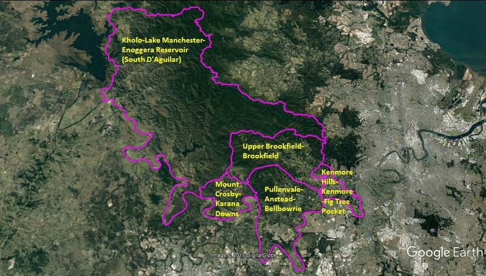
Stage 5.6 Study Areas
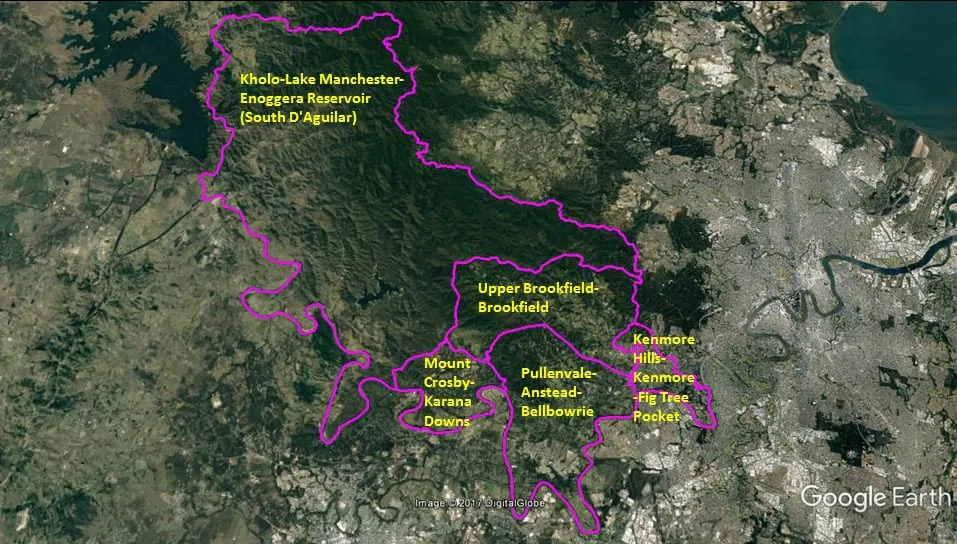

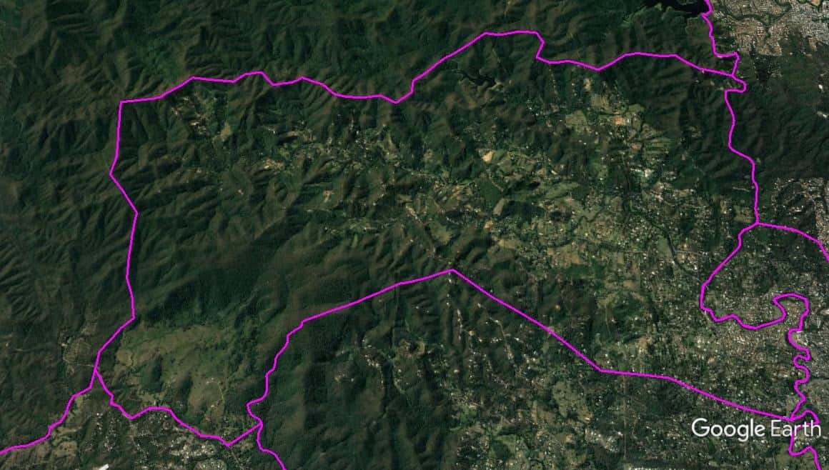
The Spatial Description of the Kholo-Lake Manchester-Enoggera Reservoir (South D’Aguilar) Local Area Study
1 mile = 1.609 km
107.1 miles (172.43 km) encirclement of MBNH LSA 1
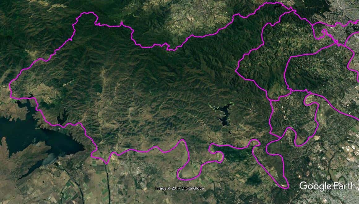
9.19 miles (14.79 km) on Northern West-East boundary, T-Junction Intersection of Wivenhoe Somerset Road and Northbrook Parkway, follow Northbrook Parkway eastward, to a point on (Lat. 27°20’04.7″S, Lon. 152°46’03.5″E; Mount Glorious Cafe) on the Mount Glorious Road.
34.91 miles (56.21 km) on Eastern North-South boundary, a point on (Lat. 27°20’04.7″S, Lon. 152°46’03.5″E; Mount Glorious Cafe) on the Mount Glorious Road, to a point (Lat. 27°26’45.80″S, Lon. 152°55’31.16″E) on the northern shore of the Enoggera Reservoir, following the reservoir wall southward, across the southern shore of the reservoir to a point (Lat. 27°26’55.00″S, Lon. 152°55’33.76″E), following a ridge line to a peak at a point (Lat. 27°27’27.54″S, Lon. 152°55’33.56″E), and across to a point (Lat. 27°27’26.12″S, Lon. 152°55’49.17″E) on Dillon Road.
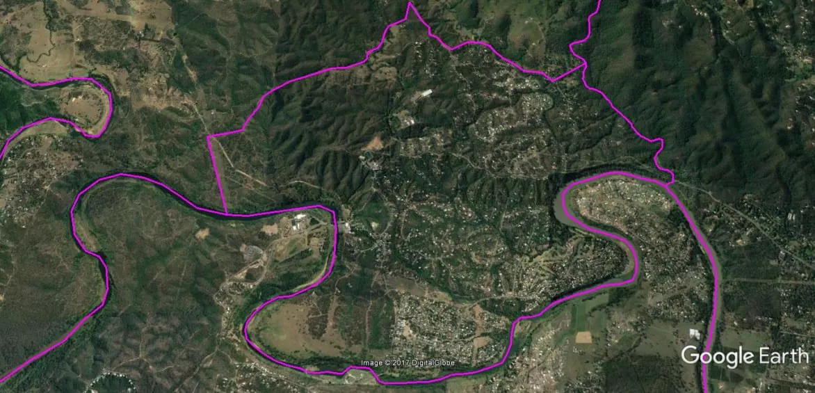
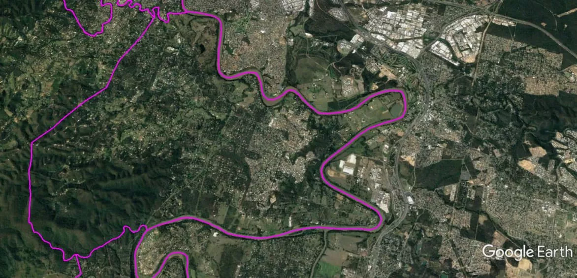
52.4 miles (84.33 km) on Southern East-West boundary, a point (Lat. 27°27’27.54″S, Lon. 152°55’33.56″E), and across to a point (Lat. 27°27’26.12″S, Lon. 152°55’49.17″E) on Dillon Road, following the ridge-lines westward (see satellite image), to a peak at a point (Lat. 27°27’4.22″S, Lon. 152°52’51.98″E) above Gold Creek Dam, follow ridge-lines southward a point (Lat. 27°27’49.80″S, Lon. 152°51’45.00″E), to a point (Lat. 27°27’49.75″S, Lon. 152°51’44.90″E), follow ridge-lines westward a point (Lat. 27°27’40.41″S, Lon. 152°48’39.79″E), due south descending a series of ridge-lines to a point (Lat. 27°30’18.48″S, Lon. 152°48’33.69″E) on Lake Manchester Road (see satellite image), roughly following the series of ridge-lines southward (see satellite image) to a point (Lat. 27°31’28.84″S, Lon. 152°47’1.76″E) on the peak of nearest mountain to Stumers Road a straight line across to a point (Lat. 27°31’31.47″S, Lon. 152°46’42.73″E) on the north-west corner of the Mouth Crosby suburb boundary, follow a straight-line on the Mouth Crosby suburb boundary southward toa point (Lat. 27°32’10.50″S, Lon. 152°46’56.04″E) on the south-west corner of the Mouth Crosby suburb boundary, following the Brisbane River upriver to Brisbane Valley Highway Bridge.
10.6 miles (17.1 km) on Western South-North boundary, from the Brisbane Valley Highway Bridge, follow the Brisbane Valley Highway to the T-Junction Intersection with Wivenhoe Somerset Road, follow Wivenhoe Somerset Road until the T-Junction Intersection of Wivenhoe Somerset Road and Northbrook Parkway.
The Spatial Description of the Mount Crosby-Karana Downs Local Area Study
1 mile = 1.609 km
16.44 miles (26.46 km) encirclement of MBNH LSA 2
5.57 miles (9.96 km) on Northern West-East boundary, a point (Lat. 27°31’31.85″S, Lon. 152°46’42.31″E) on the north-west corner of the Mouth Crosby suburb boundary (near Stumers Road), a straight line across to a point (Lat. 27°31’28.84″S, Lon. 152°47’1.76″E) on the peak of nearest mountain, roughly following the series of ridge-lines northward (see satellite image) to a point (Lat. 27°30’18.48″S, Lon. 152°48’33.69″E) on Lake Manchester Road (see satellite image), on following Lake Manchester Road southward to the junction with Swensons Road, follow Swensons Road southward to a point (Lat. 27°31’3.02″S, Lon. 152°49’52.66″E) before Flaggy Creek Road, a straight line to a point (Lat. 27°30’53.28″S, Lon. 152°50’12.02″E) on Flaggy Creek.
1.68 miles (2.70 km) on Eastern North-South boundary, to a point (Lat. 27°30’53.28″S, Lon. 152°50’12.02″E) on Flaggy Creek, follow Flaggy Creek to the mouth of Flaggy Creek on the Brisbane River.
8.41 miles (13.54 km) on Southern East-West boundary, the mouth of Flaggy Creek on the Brisbane River, follow Brisbane River upstream, a point (Lat. 27°32’10.50″S, Lon. 152°46’56.04″E) on the south-west corner of the Mouth Crosby suburb boundary.
0.78 miles (1.26 km) on Western South-North boundary, a point (Lat. 27°32’10.50″S, Lon. 152°46’56.04″E) on the south-west corner of the Mouth Crosby suburb boundary to a point (Lat. 27°31’31.85″S, Lon. 152°46’42.31″E) on the north-west corner of the Mouth Crosby suburb boundary (near Stumers Road).
The Spatial Description of the Pullenvale-Anstead-Bellbowrie Local Area Study
1 mile = 1.609 km
25.86 miles (41.56 km) encirclement of MBNH LSA 3
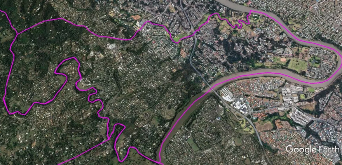
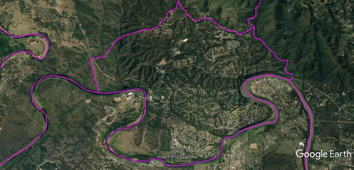
5.47 miles (8.80 km) on Northern West-East boundary, a point (Lat. 27°30’53.28″S, Lon. 152°50’12.02″E) on Flaggy Creek, follow Flaggy Creek up to the headwater in a line of mountain stream (see satellite image) to a point (Lat. 27°30’2.79″S, Lon. 152°50’39.16″E) at the peak of a mountain, follow ridge-lines northward across the next two mountain peaks and at a point (Lat. 27°29’38.28″S, Lon. 152°52’13.13″E ) on Crows Ash Road, follow descending ridge-line southward (see satellite image) reflecting the Brookfield southern suburb boundary to a point (Lat. 27°31’10.75″S, Lon. 152°55’24.98″E ) on Moggill Creek near the T- Junction Intersection of Pullenvale and Moggill Roads.
1.28 miles (2.06 km) on Eastern North-South boundary, a point (Lat. 27°31’10.75″S, Lon. 152°55’24.98″E ) on Moggill Creek near the T- Junction Intersection of Pullenvale and Moggill Roads, follow Moggill Creek to the mouth of Moggill Creek on Brisbane River.
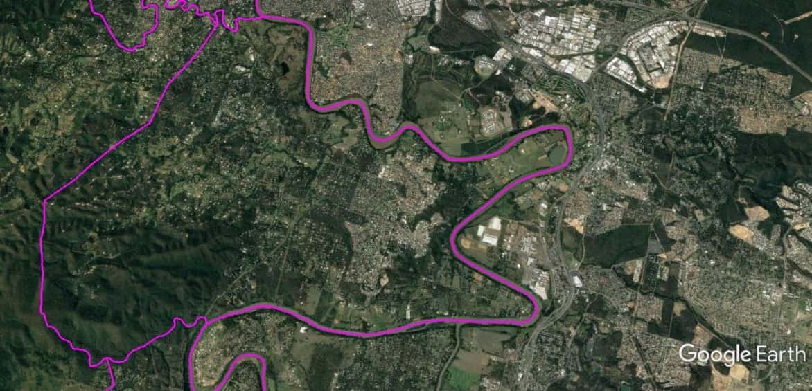
15.97 miles (25.70 km) on Southern East-West boundary, the mouth of Moggill Creek on Brisbane River, follow Brisbane River upstream to the mouth of Flaggy Creek.
3.14 miles (5.0 km) on Western South-North boundary, the mouth of Flaggy Creek on the Brisbane River, follow Flaggy Creek to a point (Lat. 27°30’53.28″S, Lon. 152°50’12.02″E) on Flaggy Creek.

The Spatial Description of the Upper Brookfield-Brookfield Local Area Study
1 mile = 1.609 km
27.12 miles (43.69 km) encirclement of MBNH LSA 4
11.9 miles (19.2 km) on Northern West-East boundary, a point (Lat. 27°30’18.48″S, Lon. 152°48’33.69″E) on Lake Manchester Road (see satellite image), due north ascending a series of ridge-lines to a point (Lat. 27°27’40.41″S, Lon. 152°48’39.79″E), follow ridge-lines eastward to a point (Lat. 27°27’49.75″S, Lon. 152°51’44.90″E), follow ridge-lines northward a point (Lat. 27°27’49.80″S, Lon. 152°51’45.00″E), following the ridge-lines eastward to a peak at a point (Lat. 27°27’4.22″S, Lon. 152°52’51.98″E) above Gold Creek Dam(see satellite image), follow across to a point (Lat. 27°27’26.12″S, Lon. 152°55’49.17″E) on Dillon Road.
6.73miles (10.82 km) on Eastern North-South boundary, to a point (Lat. 27°27’26.12″S, Lon. 152°55’49.17″E) on Dillon Road, follow Dillon Road southward which becomes Gap Creek Road, and reaching a point (Lat. 27°29’21.20″S, Lon. 152°55’33.18″E) on Gap Creek Road, near Moggill Creek, follow Moggill Creek downstream to a point (Lat. 27°31’10.75″S, Lon. 152°55’24.98″E ) on Moggill Creek near the T- Junction Intersection of Pullenvale and Moggill Roads.
6.69 miles (10.77 km) on Southern East-West boundary, a point (Lat. 27°31’10.75″S, Lon. 152°55’24.98″E ) on Moggill Creek near the T- Junction Intersection of Pullenvale and Moggill Roads, follow descending ridge-line northward (see satellite image) reflecting the Brookfield southern suburb boundary to a point (Lat. 27°29’38.28″S, Lon. 152°52’13.13″E ) on Crows Ash Road, follow ridge-lines northward across the next two mountain peaks to a point (Lat. 27°30’2.79″S, Lon. 152°50’39.16″E) at the peak of a mountain, follow Flaggy Creek headwater downstream (see satellite image) to a point (Lat. 27°30’53.28″S, Lon. 152°50’12.02″E) on Flaggy Creek.
1.80 miles (2.90 km) on Western South-North boundary, a point (Lat. 27°30’53.28″S, Lon. 152°50’12.02″E) on Flaggy Creek in a straight line to a point (Lat. 27°31’3.02″S, Lon. 152°49’52.66″E) above Flaggy Creek Road on Swensons Road, follow Swensons Road northward, at the junction with Lake Manchester Road follow road northward to a point (Lat. 27°30’18.48″S, Lon. 152°48’33.69″E) on Lake Manchester Road (see satellite image).
The Spatial Description of the Kenmore Hills-Kenmore-Fig Tree Pocket Local Area Study
1 mile = 1.609 km
15.53 miles (25 km) encirclement of MBNH LSA 5
4.85 miles (7.80 km) on Western South-North boundary (main), a point (Lat. 27°31’10.75″S, Lon. 152°55’24.98″E ) on Moggill Creek near the T- Junction Intersection of Pullenvale and Moggill Roads, Moggill Creek upstream to a point (Lat. 27°29’21.20″S, Lon. 152°55’33.18″E) on Gap Creek Road, near Moggill Creek.
4.47 miles (7.20 km) on Eastern North-South boundary, a point (Lat. 27°29’21.20″S, Lon. 152°55’33.18″E) on Gap Creek Road, following an alignment into Hillcrest Place, at the intersection of Hillcrest Place and Bielby Road, following Bielby Road southward, becomes Cedarleigh Road before reaching Moggill Road, following Moggill Road eastward, at the Moggill Road bridge over Cubberie Creek, following Cubberie Creek downstream to the Brisbane River.
4.89 miles (7.88 km) on Southern East-West boundary, mouth of the Cubberie Creek following the Brisbane River upriver to the mouth of Moggill Creek.
1.32 miles (2.12 km) on Western South-North boundary (minor), the mouth of Moggill Creek to a point (Lat. 27°31’10.75″S, Lon. 152°55’24.98″E ) on Moggill Creek near the T- Junction Intersection of Pullenvale and Moggill Roads.