Indigenous Sites across Brisbane Northside: Ray Kerkhove
Stage 5.11 Study Areas
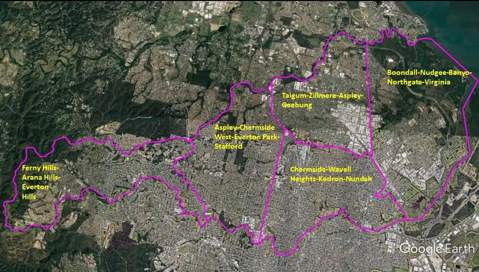
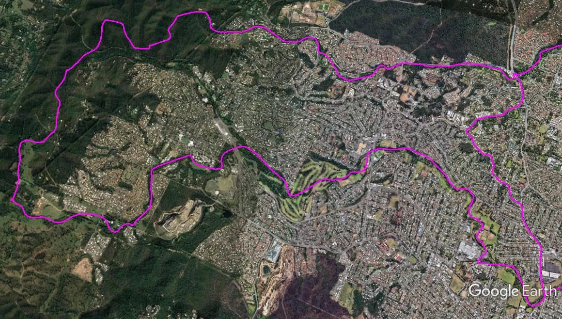
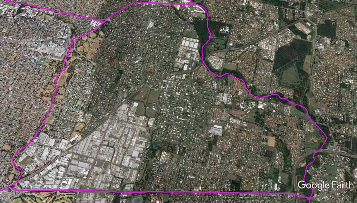
The Spatial Description of the Ferny Hills-Arana Hills-Everton Hills Local Area Study
1 mile = 1.609 km
18.61 miles (19.94 km) encirclement of MBNH LSA 17
5.42 miles (8.72 km) on Northern West-East boundary, a point (Lat. 27°23’21.94″S, Lon. 152°54’38.20″E) along the Brisbane City Council boundary on the peak of a mountain (in Ferny Hills) across from Maureen Lawrence Park and above the north side of Samford Road, following the Brisbane City Council boundary and the natural drainage into the headwaters of the Cabbage Tree Creek (the south-side of the same mountain forms another natural drainage into the headwaters of Kedron Brook), following Cabbage Tree (Tighgum) Creek upstream to Old Northern Road bridge.
2.88 miles (4.63 km) on Eastern North-South boundary, the Old Northern Road bridge over Cabbage Tree (Tighgum) Creek, follow Old Northern Road southward to Queens Road (off-ramp to roundabout below the overpass), follow Queens Road westward to the junction with South Pine Road, follow South Pine Road southward to re-join Old Northern Road to become South Pine Road, follow South Pine Road southward to South Pine Road bridge across Kedron Brook.
7.95 miles (12.63 km) on Southern East-West boundary, South Pine Road bridge across Kedron Brook, following Kedron Brook upstream to the junction with Cedar Creek, following Cedar Creek upstream to a point (Lat. 27°25’11.20″S, Lon. 152°54’17.15″E) at the natural drainage into its headwater.
2.36 miles (3.80 km) on Western South-North boundary, a point (Lat. 27°25’11.20″S, Lon. 152°54’17.15″E) at the natural drainage into the headwater of Cedar Creek, following the Brisbane City Council boundary northward to a point (Lat. 27°23’21.94″S, Lon. 152°54’38.20″E) on the peak of a mountain (in Ferny Hills) across from Maureen Lawrence Park and above the north side of Samford Road.

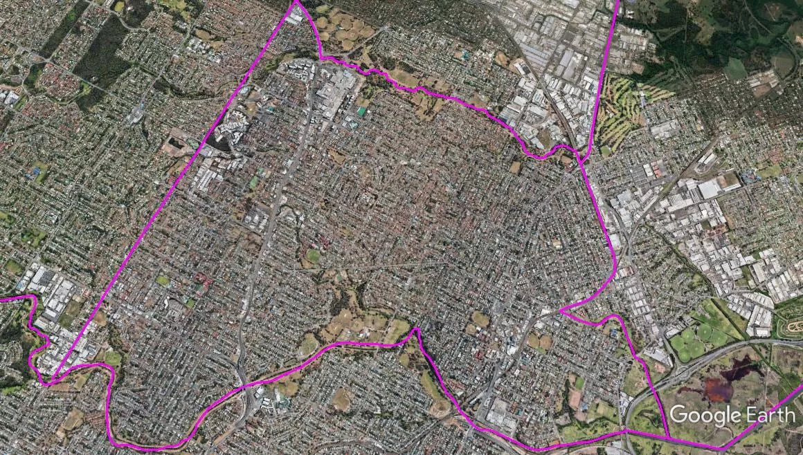
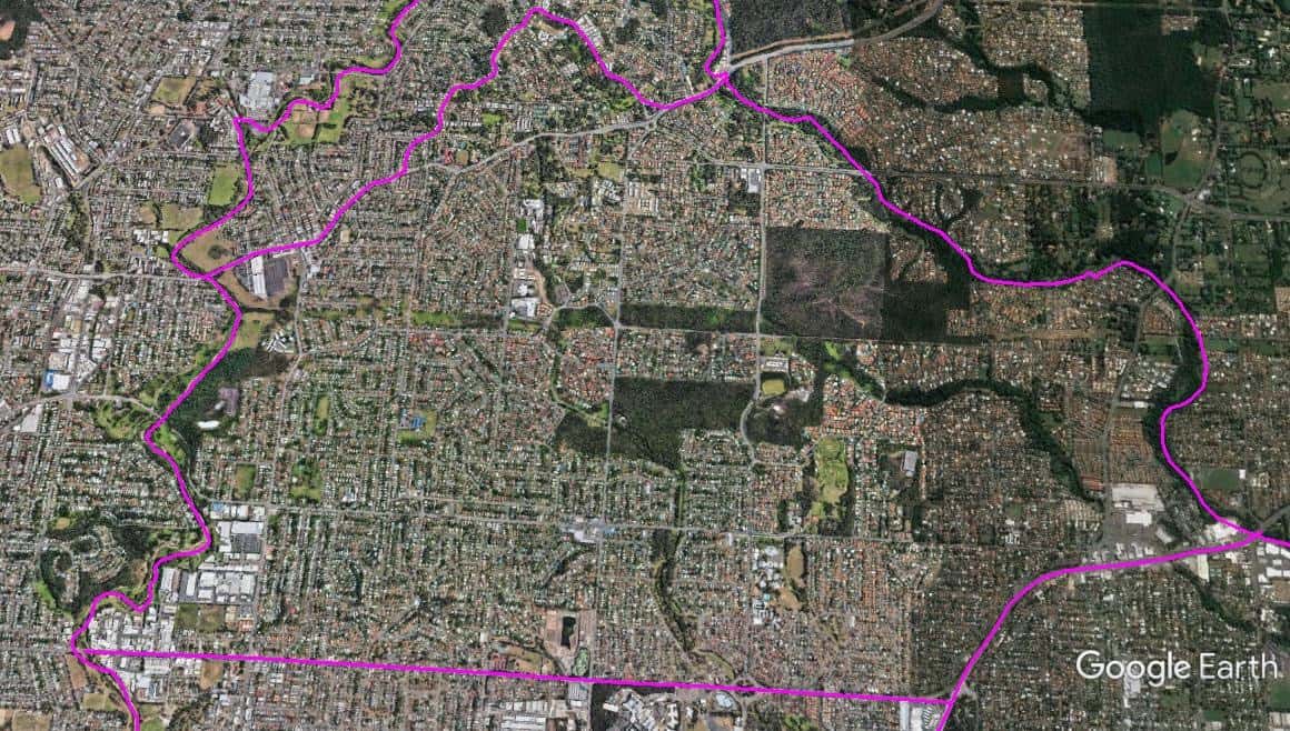
The Spatial Description of the Aspley-Chermside West-Everton Park-Stafford Local Area Study
1 mile = 1.609 km
13.04 miles (20.96 km) encirclement of MBNH LSA 18
3.49 miles (5.62 km) on Northern West-East boundary, Old Northern Road bridge over Cabbage Tree (Tighgum) Creek, follow Cabbage Tree (Tighgum) Creek downstream to Gympie Road crossing of Cabbage Tree (Tighgum) Creek.
4.56 miles (7.32 km) on Eastern North-South boundary, Gympie Road crossing of Cabbage Tree (Tighgum) Creek, follow Gympie Road southward to the T-Junction Intersection of Webster Road, follow Webster Road southward to the Webster Road bridge over Kedron Brook .
2.11 miles (3.39 km) on Southern East-West boundary, Webster Road bridge over Kedron Brook, follow Kedron Brook upstream to South Pine Road bridge across Kedron Brook.
2.88 miles (4.63 km) on Western South-North boundary, South Pine Road bridge across Kedron Brook, follow South Pine Road northward (continue with South Pine Road when South Pine Road main path becomes Old Northern Road) to the junction with Queens Road follow Queens Road westward to Old Northern Road, follow Old Northern Road to the Old Northern Road bridge over Cabbage Tree (Tighgum) Creek.
The Spatial Description of the Chermside-Wavell Heights-Kedron-Nundah Local Area Study
1 mile = 1.609 km
15.01 miles (24.14 km) encirclement of MBNH LSA 19
2.76 miles (4.44 km) on Northern West-East boundary, the T-Junction Intersection of Webster and Gympie Roads, follow Gympie Road southward to Gympie Road crossing of Downfall Creek, follow Downfall Creek (7th Brigade Park) downstream to railway crossing of Downfall Creek,
2.50 miles (4.03 km) on Eastern North-South boundary, the railway crossing of Downfall Creek, follow railway line inbound to railway meeting point (crossing of drain, creek peats out at this point) of Cannery Creek, follow Cannery Creek downstream to its junction with Kedron Book/Schultz Canal.
5.19 miles (8.35 km) on Southern East-West boundary, the junction of Cannery Creek and Kedron Book/Schultz Canal, following Kedron Brook upstream to the Webster Road bridge over Kedron Brook.
4.56 miles (7.32 km) on Western South-North boundary, the Webster Road bridge over Kedron Brook, follow Webster Road northward to the T-Junction Intersection with Gympie Road.
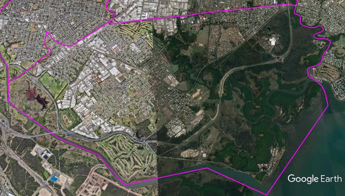
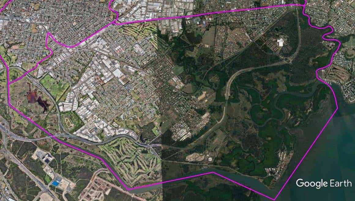
The Spatial Description of the Boondall-Nudgee-Banyo-Northgate-Virginia Local Area Study
1 mile = 1.609 km
15.2 miles (24.47 km) encirclement of MBNH LSA 20
2.74 miles (4.41 km) on Northern West-East boundary, Sandgate Road bridge over Cabbage Tree (Tighgum) Creek, follow Cabbage Tree (Tighgum) Creek downstream to the mouth of Cabbage Tree Creek in Moreton Bay.
1.72 miles (2.76 km) on Eastern North-South boundary, the mouth of Cabbage Tree Creek, following the foreshore of Moreton Bay southward to mouth of Kedron Book/Schultz Canal.
4.94 miles (7.96 km) on Southern East-West boundary, mouth of Kedron Book/Schultz Canal, following Kedron Brook/Schultz Canal upstream to its junction with Cannery Creek.
5.80 miles (9.34 km) on Western South-North boundary, follow Cannery Creek upstream until it peats out at the railway line, follow railway line outbound to the Sandgate Road overpass of railway line (near Virginia Railway Station), follow Sandgate Road northward to the Sandgate Road bridge over Cabbage Tree (Tighgum) Creek.
The Spatial Description of the Taigum-Zillmere-Aspley-Geebung Local Area Study
1 mile = 1.609 km
11.98 miles (19.29 km) encirclement of MBNH LSA 21
4.07 miles (6.56 km) on Northern West-East boundary, Gympie Road crossing of Cabbage Tree (Tighgum) Creek, follow Cabbage Tree (Tighgum) Creek downstream to Sandgate Road bridge over Cabbage Tree (Tighgum) Creek.
3.24 miles (5.22 km) on Eastern North-South boundary, Sandgate Road bridge over Cabbage Tree (Tighgum) Creek, follow Sandgate Road southward to the Sandgate Road overpass of railway line (near Virginia Railway Station),.
2.76 miles (4.44 km) on Southern East-West boundary, the Sandgate Road overpass of railway line (near Virginia Railway Station), follow railway line outbound to railway crossing of Downfall Creek, follow Downfall Creek upstream to Gympie Road crossing of Downfall Creek (7th Brigade Park).
1.91 miles (3.07 km) on Western South-North boundary, Gympie Road crossing of Downfall Creek (7th Brigade Park), follow Gympie Road northward to Gympie Road crossing of Cabbage Tree (Tighgum) Creek.