The following introduces Brisbane Southside History.
Brisbane’s southside is a region of an Australian city, much like any other. It a diverse collection of communities, whose origins go back to places overseas or to ancient lands. It has a transportation system, industry, retail, and commerce, education and cultural organisations. There is nothing new here. It is only in the history that we find anything unique about the region. Often that uniqueness is found by appreciating the unusual combination of common historical factors with particular times and particular persons.
There are estimates that there may have been between 5,000 to 12,000 Aboriginal persons in the Meanjin or Miganchan area (Moreton Bay region) at the time of Oxley’s arrival in 1823. By the mid-century Aboriginal communities were observed in the region as four large groupings; the North Pine and Duke of York clans, north of the river, and the Coopooroo, Chepara and Yerongpan clans on Brisbane Southside. Over time the clans were dispersed, and either wandered over to the Moreton Bay islands, or to the Darling Downs, enduring a history of frontier conflict, or removed to government-controlled reserves and church-run missions – at isolated places such as Stradbroke Island. A few Aboriginal folk struggled in the townships as fringe-dwellers and welfare-recipients. Ross Johnston writes, “Aborigines might participate occasionally in the fun of a boat race but generally they were being pushed aside from the mainstream of development in Brisbane.” Rod Fisher commented: “The overall picture is one of fierce but diffused Aboriginal resistance to European intrusion, its timing, location and extent being determined by the spread of pastoralism and the degree of force. In 1842-45, the main arena was Ipswich to Darling Downs, followed by the upper Brisbane River valley 1842-46, Logan district 1844-53, Pine River 1845-58, Wide Bay-Burnett 1850-59 and Sandgate 1853-59.”By the time the rural industries spread across the whole region of the Brisbane Southside in the 1850s, the original landscape was already in the gradual process of transformation. It changed from its virgin or natural vegetation and contours, but it was unrecognisable to the urban landscape that we understand. We can get an insight if we imagine a scene from the centre-point of the Brisbane Southside, at the strategically important Boggo (Annerley) Junction. Directly to the south were pastoral plains, scrub-land, and the country coach roads to Ipswich and Beaudesert; and to the west, the Fairfield farmland and the unmarked Brisbane River. Looking eastward through the wooded ridge was the Norman Creek valley below. If it were possible to gaze back into this past world, what we would have seen was truly amazing. In the
By the time the rural industries spread across the whole region of the Brisbane Southside in the 1850s, the original landscape was already in the gradual process of transformation. It changed from its virgin or natural vegetation and contours, but it was unrecognisable to the urban landscape that we understand. We can get an insight if we imagine a scene from the centre-point of the Brisbane Southside, at the strategically important Boggo (Annerley) Junction. Directly to the south were pastoral plains, scrub-land, and the country coach roads to Ipswich and Beaudesert; and to the west, the Fairfield farmland and the unmarked Brisbane River. Looking eastward through the wooded ridge was the Norman Creek valley below. If it were possible to gaze back into this past world, what we would have seen was truly amazing. In the 1860s the creek would have been surrounded by a deep green bushland with several cleared paddocks dotted along Logan Road. At the bottom of Ipswich Road (Buranda), were a few more paddocks and a small village at Stones Corner. Looking in the south-easterly direction, it might have been possible to see Stephen’s Tannery on the upper reaches of Norman (Ekibin) Creek, but apart from the isolated rural buildings, the view in this direction would have been completely forested — out to the Nathan ridge and Mount Gravatt, with the Mount Gravatt village hidden by the Holland Park ridge.
South Bank (South Brisbane) was the river crossing to the Moreton Bay penal settlement (Brisbane CBD) that link it with the convict-built road to Limestone (Ipswich). Very little is known about the original road but it did not follow the ridge line (as assumed), but rather skirted over to Norman Creek, and then joined the rise at what is now the Chardons Corner end of Annerley. At Four Mile Swamp (near the intersection of Beaudesert and Ipswich Roads) just below it followed roughly what became Beaudesert Road along the Moorooka rise. To the southeast of the main penal settlement, looking to the South Bank heights, was an area known as the One Mile Swamp (near the Clarence Corner end of Woolloongabba). The opening up of One Mile Swamp, along with the first docks on South Bank, in the 1850s, was the beginning in a transformation of the wider Southside landscape.Slacks Track (Logan Road) was an Aboriginal pathway used by the Slacks family to drive their livestock to the Brisbane market from the Albert and Logan river settlements. Sometime during the 1850s period, “Boggo road” formed, most probably upon an indigenous track, and linked the One Mile Swamp water reserve with a pathway up to the top of the Boggo (Annerley) ridge; connecting it with Ipswich Road. The start of Ipswich Road (a diversion from the earlier convict pathway) began with the development of the early five-way Woolloongabba intersection: Ipswich Road had been extended down the eastern side of Boggo ridge to link up with the start of the road to the Logan district, and Main Street, which met both roads, and provided the entry to the small township of Kangaroo Point.
Slacks Track (Logan Road) was an Aboriginal pathway used by the Slacks family to drive their livestock to the Brisbane market from the Albert and Logan river settlements. Sometime during the 1850s period, “Boggo road” formed, most probably upon an indigenous track, and linked the One Mile Swamp water reserve with a pathway up to the top of the Boggo (Annerley) ridge; connecting it with Ipswich Road. The start of Ipswich Road (a diversion from the earlier convict pathway) began with the development of the early five-way Woolloongabba intersection: Ipswich Road had been extended down the eastern side of Boggo ridge to link up with the start of the road to the Logan district, and Main Street, which met both roads, and provided the entry to the small township of Kangaroo Point.
The first land auction in South Brisbane was in 1843, and in 1855 building lots opened at One Mile Swamp, near Vulture Street. The swamp became a water reserve, and serviced as a rest stop for livestock. The water reserve was drained in 1889 by which time a major township had been established at Clarence Corner, and Stanley Street led through the early five-way Woolloongabba intersection.
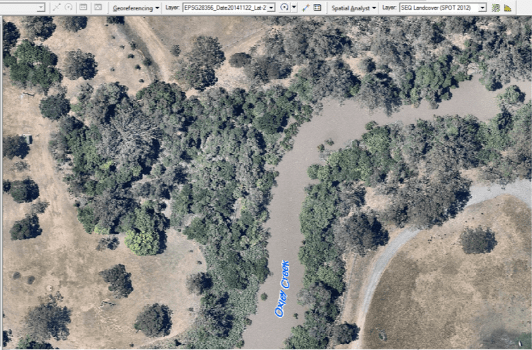
Thomas Blacket Stephens purchased one of two farms in the first land sales in the Parish of Yeerongpilly. It was 94 acres on the bank of the upper Norman Creek; that part of the creek was commonly known as “Ekibin Creek”. The western boundary of the land became Ekibin Road and the southern boundary became Gilmore Street (West) and a line to Esher Street (East). Its eastern boundary was the north-south track that crossed the creek, and part of this access roadway became Toohey Road. The property housed a number of early rural industries. In 1859 Stephens established a large wool scour, and in 1862 established a fellmongery and a tannery that employed 200 workmen. The tannery is said to have existed on the bend in Sunshine Avenue at the right from Essie Street. Stephens’ landholdings became extensive in the district, and took up what is currently the Annerley Junction area east of Ipswich Road, between what is now Dudley Street and Gowrie Street, as well as Stephens Mountain (Greenslopes Hospital area on the north bank of “Ekibin Creek”).
From 1859 Joseph Thompson developed a career as a rural entrepreneur. Thompson’s property was 200 acres. It started in the north to the present-day O’Keefe Street up to Cockerill’s paddock on the rise and followed Norman Creek. Little is known about Thompson. It is said that he cleared timber near Grimes’ farm around what is now Dutton Park. Thompson and a partner shipped to Melbourne 40,000 pine shingles from the Boggo Road scrub on the boundary of Fairfield. The key role that Joseph Thompson had is that he created, in the mid-1880s, the Thompson Estate when he sub-divided his paddocks with newly formed Carl, Fern, Oxford, Regent, Myrtle, and Junction streets.
William Henry Baynes was one of the first to establish a butchering business in the South Brisbane district, located on what was commonly referred to as Baynes’ Paddock, on the Norman Creek. With his brothers, he ran Graziers’ Butchering Company and also exported canned and salt meat beyond the British colonies (the Graziers’ Meat Export Company). Sons of William Baynes, Harry, George and Ernest, took over the commercial enterprises. The new partnership expanded with meat preserving in leased premises at Queensport, nearly thirty suburban butcher shops, a plant at Belmont for fellmongering, wool-scouring and soap-making, and a factory at South Brisbane to supply cooperage, saddlery and vehicles.
Independent government came late to the region. Brisbane’s very small municipal council formed in September 1859. The commercial hub was South Brisbane, which started as South Ward in the early Brisbane Municipal Council (made up of only four wards), and the area did not become its own township until 1887 when the former South Ward amalgamated with the division of Woolloongabba.
On 11 November 1879, the first divisional boards were established across non-urban areas of Queensland, including the Woolloongabba Divisional Board, and the Yeerongpilly Divisional Board. A realignment of the divisions occurred on 14 October 1886 with the formation of the new Stephens Division, named after Thomas Blacket Stephens. In 1902 the divisions became shires. The Stephens Divisional/Shire Office was on Ipswich Road down the hill from the Annerley Junction, near Victoria Terrace. The Yeerongpilly Divisional/Shire Office was near the Rocklea railway station.
Even before the provisions of the 1875 Education Act, elementary schools were rapidly developing among sparse rural communities. Secondary and tertiary levels of education came very late for the region, although the Brisbane Southside had some of the earliest high schools. The elementary schools were often the hub of the early farming districts and small township. Churches, lodges, and cultural societies meet frequently in school grounds, community halls, and early theatres to create large events of public entertainment. Migrant places of worship, if not in home shrines, began in the 1920s, often not cognitively visible in the perception of the dominant culture.
Hospital and cemeteries were places with a diverse cross-section of society, illness and death being the great-equalisers and the value of public health that was developed and maintained since the late nineteenth century.
Kath Ballard. Brisbane: The Beginning. Part 1 A Story of 18th Century Miganchan and its environ. Kath Ballard, 2007.
Kath Ballard. Brisbane: The Beginning. Part 2 The Story of 19th Century Moreton Bay and its environ. Kath Ballard, 2007.
Neville Buch. No Regret in the Evening of Life. The History of Junction Park State School (1888-2013). Boolarong Press. 2014.
Dianne Byrne. A travelling photographer in colonial Queensland: the work of William Boag. State Library of Queensland, 1994.
Fred Clark, Noel Hall, Noel Wallis, Jim Williamson, and Ted Dunlop. Ipswich Road 1839-2005: the history of the Brisbane to Ipswich road and its current route with references to early surveyors and coach transport. Richlands, Inala and Suburbs History Group, 2005
Christopher Dawson. 2007. Boggo Road Heritage Walk. Clarence Corner to Boggo Junction. Boggo Road Historical Society.
Christopher Dawson. 2008. The One & Only Boggo Road. The History of a Unique Suburban Street. Inside History (Boggo Road Gaol Historical Society).
Christopher Dawson. What’s in a name? The rise, fall and comeback of Boggo. Queensland History Journal, Vol. 21, No. 4, Feb 2011.
James Joseph Dempsey. History of Junction Park State School: 1888-1933. R.G. Gillies & Co. Pty. Ltd., 149 Elizabeth Street, Brisbane. 1933.
Val Donovan. The Reality of a Dark History: From Contact and Conflict to Cultural Recognition. Arts Queensland, 2002.
Raymond Evans and Carole Ferrier (Edited). 2004. Radical Brisbane. An Unruly Brisbane. The Vulgar Press.
Erica Ferroff (Edited). 1988. A Century of Achievement. A History of The Centenary Committee of the Junction Park State School. Junction Park State School and the Annerley District. The Centenary Committee of the Junction Park State School.
Rod Fisher. The best of colonial Brisbane. Boolarong Press, 2012.
Rod Fisher. (Edited) Brisbane: houses, gardens, suburbs and congregations. Brisbane History Group 2010.
Rod Fisher. Brisbane: people, places and progress. Brisbane History Group, 1994.
Rod Fisher. Brisbane in 1888: The Historical Perspective. Brisbane History Group, 1988.
Geoff Gaylard. The Moreton Bay Courier to the Courier-Mail 1846-1992. Portside Editions, 1992.
Ros Gillespie. Boggo, Yeronga, and Beyond, Leaving Footprints, Making Pathways. Yeronga State School, The Story of 125 Years: a school, a community and a locality. Yeronga State School, 1996.
Murray Johnson. Brisbane: Moreton Bay matters. Brisbane History Group, 2002.
Ross Johnston. Brisbane: The First Thirty Years. Boolarong Press, 1988.
John Kerr (Edited). 1997. The Annals of Annerley. Proceedings of the Annerley Conference. 17 July 1994. Royal Historical Society of Queensland.
Tom King. Boggo Road & Beyond. King, 2007.
John Laverty. The Making of a Metropolis: Brisbane 1823-1925. Boolarong Press, 2009.
Jim Lergessner. 2009. Snippets…from A Baby Boomer’s Diary. Dr James G. Lergessner.
Annabel Lloyd. Detail Plans for Surveyors Plan Field Book. Brisbane City Archives, March 2007, in 1916-1935. Comparison Survey Plans for Junction Park. NDB Document No. BCA.
Hugh Lunn. 1989. Over the Top With Jim. ABC Books. 2007 Edition.
Anne MacKenzie. Memories Along the Boggo Track. Boolarong Press, 1992.
Frank McBride. Brisbane: 150 stories, 1858-2009. Brisbane City Council, 2009.
Nat McCaughey. The Dungarees: an account of the recruitment march from Warwick to Brisbane by volunteers for the First World War and the re-enactment 1998. Dungarees March Re-enactment Association, 2000.
Alan Reeve North. Thomas Mathewson, father of photography in Queensland: an early pioneer, photographer, historian, 1842 to 1934.
Juliet O’Brien and George D. Dean. A History of Wellers Hill, Tarragindi and Ekibin, 1850-1976. The Authors, 1976.
Mamie O’Keeffe. Convicts at Moreton Bay: 1824-1859. Royal Historical Society of Queensland, 2001.
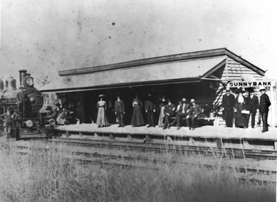
Graham Payne and Lyn McAndrew (Edited). Paddocks to Pavements. A folk history of the Sunnybank District to honour the centenary of the extension of the railway, 1885-1985. Sunnybank State High School Parents’ and Citizen’s Association. 1985.
Beryl Roberts. Stories of the Southside. Volume I. Aussie Books. 1991.
Beryl Roberts. Stories of the Southside. Volume II. Q.V. Books. 2012.
Peter Spearitt. Seeing Brisbane 1881-2001. The Brisbane Institute, 2002.
Ray Thyers. Ray Thyer’s 19th century chronology: years 1800 to 1900: a wonderful journey through time of the beautiful city of Brisbane, Queensland, Australia. Grand Wisdom Publisher, 2008.
Ray Thyers. Ray Thyer’s 20th century chronology: years 1900 to 2000: a wonderful journey through time of the beautiful city of Brisbane, Queensland, Australia. Grand Wisdom Publisher, 2008.
Unnamed. Brisbane town news: from the Sydney Morning Herald 1842-46. Brisbane History Group, 1989.
Unnamed. Brisbane by 1888: the public image. Brisbane History Group, 1988.