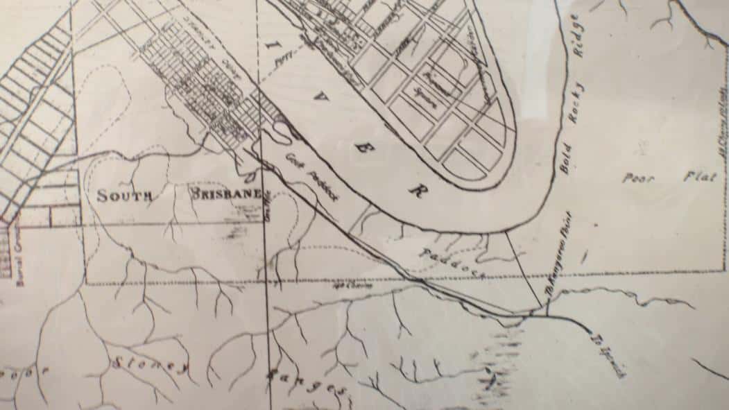
South Bank (South Brisbane) was the river crossing to the Moreton Bay penal settlement that linked it with the convict-built Limestone road. Very little is known about the original road but it did not followed the ridge line (as assumed), but rather skirted over to Norman Creek, and rejoined the rise at what is now the Chardons Corner end of Annerley. At Four Mile Swamp (near the Beaudesert and Ipswich Road intersection) just below it followed roughly what became Beaudesert Road along the Moorooka rise. To the southeast of the main penal settlement, looking to the South Bank heights was an area known as the One Mile Swamp (Clarence Corner end of Woolloongabba).
The general topography of region was a significant determinant in the positioning of roadways in the early settlement. In hilly places, with steep inclines and sometimes rocky outcrops, like the sections of Gladstone/Annerley/Ipswich Roads, the pathways tended to follow the line of the ridges to enable all weather access. The roads in gully areas were subject to flash flooding and easily became boggy and inaccessible.
Slacks Track (Logan Road) was an Aboriginal pathway used by the Slack family to drive their livestock to the Brisbane market from the Albert and Logan River settlements. Sometime during this period of the 1850s, “Boggo road” formed, most probably upon an Indigenous track, and linked the One Mile Swamp water reserve with a pathway up to the top of the Boggo (Annerley) ridge; connecting it with Ipswich Road. The start of Ipswich Road (a diversion from the earlier convict pathway) began with the development of the early five-way Woolloongabba intersection: Ipswich Road had been extended down the eastern side of the Boggo ridge to link up with the start of the road to the Logan district, and Main Street, which met both roads, and became the entry to the small township of Kangaroo Point.
Large horse-drawn drays, heavily laden with farm produce, were important early road users. They transported loads of corn, potatoes, pumpkins, oatmeal, vegetables, lucerne, chaff and hay to the markets. Heavy loads of cedar boards and planks cut by hand in long pit saws, were laboriously hauled by slow bullock teams along these vital overland arteries. After rain the animal hooves and steel-rimmed wheels of these transport vehicles quickly cut up the roads and made conditions very dangerous.
In 1873 the licensing of cabs and omnibuses commenced. The largest omnibus company in the area belonged to the John Soden and his family who lived just below Chardon’s Corner with their workshop. Private bus companies dominated the Brisbane southside before the growth of the Brisbane City Council bus services in the 1940s and 1950s, which tended to first reflect the tram routes from north to south. Private transport as recreational activity became the normal eventually, leaving public transport to mainly morning and afternoon work runs into the city. However, at first it was fairly exclusive. The Brisbane Bicycle Club was formed in 1881, and it was a fairly socially restricted affair. On the Brisbane Southside, it has only been in later decades that Yeronga, Dutton Park, and Highgate Hill have become an important cycle run. The creek systems in Brisbane have never been developed to create interconnecting bike pathways, as it had in Melbourne, although the South-East Freeway provided a limited connecting pathway to southern suburbs.
The most important bridge link was the first temporary wooden bridge connecting North Brisbane to South Brisbane built in 1865. This vital cross river connection was an expensive construction for early Brisbane residents and the inexperienced and underfunded Brisbane Municipal Council. The bridge, later known as Victoria Bridge, had to be re-built four times (1865, 1874, 1897, 1969). The Grey Street or William Jolly Bridge (1932) assisted entry to South Brisbane, but is was the Story Bridge opening in 1940 that produced a major gateway in and out of Brisbane Southside.
Boats and shipping services were the earliest forms of commercial transport along the Brisbane River. It gave South Bank its importance from the start of the post-penal settlement. The docks at South Brisbane were easier to access at that stretch of the river. The commercial success of the Eagle Street pier came in a later era, by which time the South Brisbane docks were riding on the success of coal exports. Other Brisbane Southside suburbs were also able to make important use of the river. Bulimba became the centre for ship-building. The launch of a vehicular steam ferry to Bulimba in 1886, marked another north-south access, one away from the inner-city traffic. Mowbray Park in East Brisbane and Orleigh Park in West End are the best examples of the city’s riverside reserves, combining recreation and public transport needs. The West End to Toowong ferry began operating in 1876. Public baths (swimming areas) were established on the banks of the river, for example at Dutton Park near the bottom of the South Brisbane cemetery.
The coming of the railway on the Brisbane Southside was a game-changer. Initially, a coal line was built from Chemler, off the Ipswich-Brisbane track, that ran across the southside from Yeerongpilly to the South Brisbane docks via Woolloongabba. It was in 1885 that the South Coast Line was opened from South Brisbane station to Loganlea, with the line being built to Southport in the late 1880s. The rail line that connected the suburbs from Buranda across to Cannon Hill and to the bay suburbs of Wynnum-Manly, came shortly afterwards. The development of the suburban railway was closely interwoven with real estate spreading southward. In some cases the Bay and South Coast lines galvanized small communities. The opening of the Sunnybank railway station marked the formal beginning of the rural township, with better access between farm and market.
The tramway also added to the urban growth corridors. Its importance to the community can be seen in the fact that the practice of posting letters on tramcars in Brisbane began in 1894. The West End, Dutton Park, Balmoral, Salisbury and Mount Gravatt tram services became the mainstay of public transport in the mid-twentieth century. The Belmont Tramway to Norman Park opened in 1912, and was a light rail commercial service. In 1951 Brisbane trolley buses began operation, but had very restricted services. In the 1960s main road access to the city and outer suburbs became the focus of urban planning, and as a consequence the tramway fell out of favour. The last tram runs in Brisbane occurred in 1969, and coincided with the construction of the Captain Cook Bridge (1972) and the first stage of the South-East Freeway to Woolloongabba, and later to Juliette Street, Buranda.
The opening of Archerfield aerodrome around 1931 was one form of transportation that linked the southside to the country. Lores Bonney sets a new Australian record for the longest distance flown in a day, in 1932, departing from Archerfield aerodrome and flying to Wangaratta.