Stage Number: MBSH.05.03.10
Group: Western
Local Study Area: Seventeen Mile Rocks-Darra
Epoch: Late 19th Century
Street Address: Left and right sides of lower Counihan Rd, Seventeen Mile Rocks
Latitude & Longitude: -27.53883333,152.95936111
Time Link: 1887
Map Link: TBA
Image Time Point: TBA
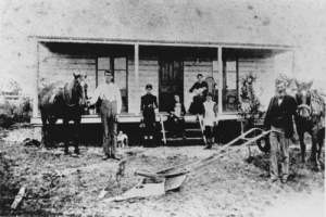
Early settler John Vincent Magee worked the riverfront portion to the west side of what is now Counihan Road, and his family continued to operate a market garden there for many years, during a period when most of the Seventeen-Mile Rocks farming district was used for dairy farming. Typical crops of the time were potatoes, sweet potatoes, pumpkin and corn, and a variety of green vegetables, although there was some experimentation with sugar cane and cotton. The family supplied the Army with vegetables During World War II, as well as taking their produce to market.
Centenary Suburbs Historical Society, ‘Agriculture and Market Gardens – Rocks Riverside Park & vicinity’ (https://cshsoc.files.wordpress.com/2015/11/agriculture-market-gardens-at-rocks-riverside-park.pdf), sighted 18 July 2017.
John Magee and family at their home in Seventeen Mile Rocks, Brisbane, ca. 1887. John Oxley Library, State Library of Queensland, Record number: 71635.
Currently Searching
