Stage Number: MBSH.03.02.28
Group: Southern
Local Study Area: Kangaroo Point-East Brisbane
Epoch: Early 19th Century
Street Address: 768 Main Street, Kangaroo Point
Latitude & Longitude: -27.48258333,153.03611111
Time Link: 1856
Map Link: 1865
Image Time Point: 1865
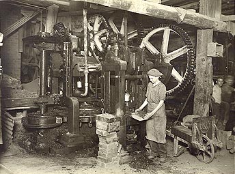
The development of the One-mile Swamp (later to become Woolloongabba) area during the 1860s was aided by the discovery of good beds of clay around the series of waterholes there. The first of several brickworks in the local area was established near what is now the Woolloongabba cricket ground circa 1856 by two men named Stonbridge and Birch. It is likely that the bricks used in the construction of surviving buildings such as Pollock’s shop-house on Stanley Street came from the One-mile Swamp brickworks. The pits covered a large area, and long rows of drying bricks could be seen lying on the ground prior to firing in the kiln. Other local brickworks were afterwards established by James Shirley and James Duncan on what is now Princess Street, and by Stephen Potter on Ipswich Road in 1863. The bricks from local yards like these were used in the construction of such major facilities as the South Brisbane Dry Dock and the Boggo Road prison.
Department of Environment and Heritage Protection, Queensland Heritage Register, ‘Pollock’s Shop House’; Brisbane Courier, 8 September 1923.
A brickmaking factory in Brisbane, circa 1920s. Brisbane City Council. Brisbane Images. Record number BCC-B120-30482.
QSA. QSA Series ID 2043 City of Brisbane and Suburbs Maps – A1A Series. 1 chain to the inch. Plan of subdivision of section 30 City of Brisbane. 1 chain to an inch. Surveyor General’s Office, Brisbane.(quarter-size). 634488