Stage Number: MBSH.05.01.20
Group: Western
Local Study Area: Chelmer-Graceville-Sherwood
Epoch: Early 20th Century
Street Address: 669 Sherwood Rd, Sherwood
Latitude & Longitude: -27.53233333,152.98158333
Time Link: 1921
Map Link: 1920
Image Time Point: 1920
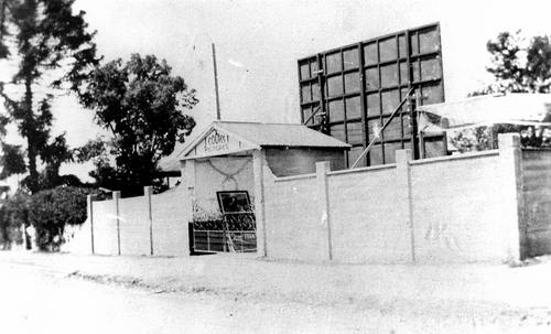
The Sherwood Theatre opened in September 1921 as an open-air movie theatre. It was also used for church services after the nearby St Matthew’s Church was destroyed by fire that same month. The theatre was originally known as Cooks Pictures and was owned by Boer War veteran and Queensland cricket representative ‘Barney’ Cook. It had various other names over the years, including the Prince of Wales, the Sherwood Theatre, Sherwood Picture Pavilion, and the Netherland Club.
Daily Mail, 1 August 1920; Brisbane Courier, 26 April 1932; Telegraph, 16 March 1944.
Cooks Pictures at Sherwood, Queensland, ca. 1925. John Oxley Library, State Library of Queensland, Record number: 447553.
QSA. QSA Series ID 2043 City of Brisbane and Suburbs Maps – A1A Series. 20 chains to the inch. Brisbane and suburbs street and road map showing railway lines and tramway routes, with radial lines at one mile intervals from the GPO. 20 chains to the inch.. 634570
